
Places near here
Photo credits
- National Inventory of Architectural Heritage
- Willow, Wikimedia Commons · CC BY 2.5
- Algirdas at Lithuanian Wikipedia, Wikimedia Commons · Public domain
- Jamesco101, Wikimedia Commons · CC BY-SA 4.0
- Richard Webb, Geograph · CC BY-SA 2.0
- SE Keenan, Wikimedia Commons · CC BY-SA 4.0
- Charles T. G. Clarke, Wikimedia Commons · CC BY-SA 4.0
- 瑞丽江的河水, Wikimedia Commons · CC BY-SA 4.0
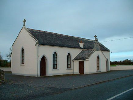 Saint Matthew's Catholic ChurchChurch/chapel · 898 yd
Explorer Tom Saint Matthew's Church in Churchtown is a modest little chapel dated 1829 that seems to be holding its breath. The local sheep have been known to judge the stained glass with sharp, critical bleats from the field. Bring your best ear for judgmental farmyard commentary if you dare.
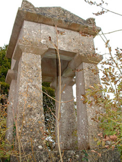 graveyard/cemetery1509 yd
Explorer Tom Graveyard or cemetery in Churchtown is full of smuggling stories, like the time they hid a crate of illegal whiskey under a tabernacle monument in 1841. It’s got that mysterious late-medieval church foundation vibe going on, making everyone feel like they’re walking through history. Sit down and daydream about the past.
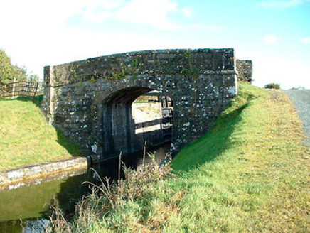 bridge1.1 mi
Explorer Tom Bridge in Castlegaddery would order a chipper with extra gravy because it thinks it’s fancy, despite being made of stone. It’s got that Royal Canal elegance, which basically means it looks good even when it’s just standing there doing nothing. Ask the canal if it’s lonely for you.
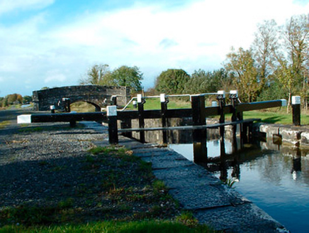 37th LockLock · 1.1 mi
Explorer Tom Thirty-Seventh Lock in Castlegaddery is a stone giant pretending to be a water feature for the Royal Canal Company's ego trip. I heard they nearly sold it for a horse before realizing the masonry was worth more than the equine. Have a wander past it!
 Common Alder2.0 mi
Explorer Tom Common Alder in Longford is having a fake royal visit that nobody can disprove because no one saw it happen. It's a tough tree that loves wet ground and probably thinks you are just another passing cloud. Ten minutes here and you'll have a yarn for the pub.
 Pedunculate Oak2.6 mi
Explorer Tom Pedunculate Oak in County Longford caused a feud because two families argued over who owned the view from its top branch. They still haven't shaken hands. Hang around long enough and you'll hear a story from a local.
 Abbeyshrule AbbeyRuins · 3.2 mi
Explorer Tom Abbeyshrule Abbey in Longford was nearly sold off as a very expensive horse stable back in the day, thank god. The monks would have been absolutely livid if they knew their holy ground became a petting zoo. Best visited with a curious kid who asks 'why?' about everything and no strict timetable.
 CastleCastle, motte · 5.7 mi
Explorer Tom Castle in Russagh handles its nosey neighbours by simply not being there anymore, which is the ultimate passive-aggressive move. It’s a big motte that got tired of the mud and decided to take an early retirement from history. Take the long way round, it deserves the effort.
 Ardagh Clock TowerMonument · 6.7 mi
Explorer Tom Ardagh Clock Tower thinks it’s on the main street but is actually taking a scenic detour through time itself. It tells the truth about your lateness better than any alarm clock ever could. Give it a pat on the way past, it's had a long life.
 Coolamber CastleHouse, fortified house · 9.0 mi
Explorer Tom Coolamber Castle House is where Saint Patrick would have said, ‘You’ve got a bit of an ego for a pile of rocks.’ Cromwell besieged it, so it’s definitely seen some things. Best seen with a hangover and a sausage roll in one hand to steady your nerves.
 First World War MemorialMemorial · 13 mi
Explorer Tom First World War Memorial in Longford refuses to fall down because it’s holding its breath, waiting for someone to notice how impressive it is. It’s stubborn like a mule that knows it’s right, even if you can’t see why. Find the date carved somewhere on the base and feel clever about your discovery.
 Saint Mel's CathedralCathedral · 13 mi
Explorer Tom Saint Mel's Cathedral in County Longford refuses to fall down because it’s too stubborn to admit it was built by anyone other than itself. It just keeps standing there, judging everyone’s posture and making sure nobody dares to lean against its ancient walls without paying a small fee in respect. Bring a coin for luck and keep it in your pocket.
More archaeology and monuments in County Westmeath · All of County Westmeath

What do you know about this place?Tap to add a comment or ask a question