What is recorded here
Paddy Row is a mill dam in Scottish Borders, Scotland.
From the Historic Environment Scotland record 343915
The historic-place record does not grant public access. Check current conditions and ownership before entering land or a building.
Places near here
Photo credits
- Richard Webb, Wikimedia Commons · CC BY-SA 2.0
- Walter Baxter, Wikimedia Commons · CC BY-SA 2.0
- Peter Wood, Wikimedia Commons · CC BY-SA 2.0
- Oliver Dixon, Wikimedia Commons · CC BY-SA 2.0
- Mike Pennington, Wikimedia Commons · CC BY-SA 2.0
- John Walton, Wikimedia Commons · CC BY-SA 2.0
- Jonathan Thacker, Wikimedia Commons · CC BY-SA 2.0
- Gordon Brown, Wikimedia Commons · CC BY-SA 2.0
 Oxnam RowCist · 436 yd
 OxnamFarmstead (medieval) · 451 yd
 OxnamFindspot, Microlith(s) · 608 yd
 War MemorialMemorial · 1320 yd
 Birks WoodForest · 1584 yd
 MillheughRoad (post Medieval) · 1651 yd
 Bush Strip WoodForest · 1.2 mi
 Dere StreetNo Class (event) (21st Century) · 1.9 mi
 MossburnfordCave · 2.2 mi
 Ferniehurst CastleCastle (medieval), Chapel (17th Century), Garden Wall(s) (17th Century), Gateway (17th Century) · 2.7 mi
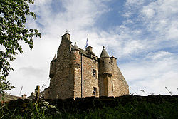 Ferniehirst CastleCastle · 2.7 mi
 Canongate BridgeMemorial · 3.2 mi
More historic places in Scottish Borders · All of Scottish Borders
What do you know about this place?