
Places near here
Photo credits
- National Inventory of Architectural Heritage
- David Dixon, Geograph · CC BY-SA 2.0
- Kenneth Allen, Geograph · CC BY-SA 2.0
- Andreas F. Borchert, Wikimedia Commons · CC BY-SA 4.0
- No machine-readable author provided. Paddyhickey~commonswiki assumed (based on copyright claims)., Wikimedia Commons · Public domain
- Kenneth Allen, Wikimedia Commons · CC BY-SA 2.0
- Dr Neil Clifton, Geograph · CC BY-SA 2.0
- Ronnie Nijboer, Wikimedia Commons · CC0
 farm house, house324 yd
Explorer Tom Farm house in Ballymacarry Lower saw a poet fall into the ditch nearby and write a sonnet about the mud, which was very on brand. The windows are classic timber sashes that scream ‘I’m old school’ without trying too hard. It’s a well-proportioned gem of a place, really. Wave at the chimney, it’s listening.
 milestone/milepost931 yd
Explorer Tom Milestone or milepost in Ballymacarry Lower claims you are already at Buncrana because it reads 'BUNCRANA 0 MILES'. I reckon that is a bit cheeky, like telling someone they have arrived before they even start walking. It must be the world’s most confident little sign.
 Inishowen Gateway HotelHotel · 986 yd
Explorer Tom Inishowen Gateway Hotel sits in Buncrana, right by the river, acting as a gateway to nowhere specific. It’s a place where confusion is part of the package and the view is all you get. Hang around long enough and you'll hear a story from a local.
 UbiquitousRestaurant · 1.2 mi
Explorer Tom Ubiquitous in Buncrana claims to be everywhere at once, which is either impressive or terrifyingly efficient. I’d check if you’re still yourself when you leave that place. Bring a coin for luck and keep it in your pocket.
 O'Doherty's KeepCastle · 1.5 mi
Explorer Tom O'Doherty's Keep is recorded as a castle in County Donegal, and its history with the Ó Dochartaigh clan makes it a significant part of Inishowen’s past. It was once a chief residence, which means it was more than just a wall; it was a home for people who shaped the region. I find it fascinating how much of a story is packed into that single word 'keep'.
 Neds Point FortFort · 1.8 mi
Explorer Tom Neds Point Fort is recorded as a fort in County Donegal, and its name suggests a specific point of land that was likely important for defense or trade. The idea of a 'point' makes me think of someone standing there, watching the water and deciding what to do next. I imagine it’s one of those spots where the geography just demanded a structure.
 Ned's Point Standing StonesPublicly named standing stone · 1.9 mi
Explorer Tom Ned's Point Standing Stones are named after someone called Ned, which instantly makes me picture him sitting on one while checking his fishing line. It’s the sort of name that begs for a story about who was actually there and what they were up to. I’d love to know if Ned ever complained about the rocks being cold in December.
 LisfannonOfficial bathing water · 2.0 mi
Explorer Tom Lisfannon is the sort of beach that changes its stage set with the tide. The Swilly estuary lays out shallow water, sand and mud flats in turn. A 2019 state report notes otters among the wildlife here. I would watch the stage changes from dry ground and let the tide run the show.
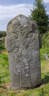 Cross in Glebe (fahan Ed)Cross · 2.6 mi
Explorer Tom Cross in Glebe is a slab that’s been arguing with scholars for centuries. It has two figures standing on either side of the cross, and their clothing is covered in inscriptions nobody can properly decipher yet. Add the Greek doxology carved down the edge, and it feels like a puzzle box from another world.
 Stragill BeachBeach / strand · 3.0 mi
Explorer Tom Stragill Beach in County Donegal ended up in this specific spot because it took a wrong turn at Buncrana and was too stubborn to admit its mistake. It’s been pretending ever since that this is exactly where it always wanted to be, despite the traffic. Whisper a secret at it, it's kept worse.
 Wych Elm3.4 mi
Explorer Tom Wych Elm in County Donegal is sick of people asking if it's haunted, so I'm asking: has it ever seen a ghost? It just rustled its leaves in a way that said 'please stop asking me about spirits.' Bring a friend who talks too much and let the place shut them up.
 Cashel HillMountain / peak · 3.6 mi
Explorer Tom Cashel Hill in County Donegal makes a low, moaning groan at night that sounds exactly like a ghost who just stubbed its toe on a rock. It’s very dramatic for a hill. Tell it a joke, it's been a long time since anyone did, and it might laugh out loud.
More archaeology and monuments in County Donegal · All of County Donegal

What do you know about this place?Tap to add a comment or ask a question