
Places near here
Photo credits
- Wanfried-Dublin, Wikimedia Commons · CC BY 4.0
- John M, Wikimedia Commons · CC BY-SA 2.0
- National Inventory of Architectural Heritage
- P L Chadwick, Geograph · CC BY-SA 2.0
- Gerald England, Geograph · CC BY-SA 2.0
- Tony Webster from Portland, Oregon, United States, Wikimedia Commons · CC BY 2.0
- John M, Geograph · CC BY-SA 2.0
- Sue Mulvihill, Wikimedia Commons · CC BY-SA 2.0
- Michael Earnshaw, Geograph · CC BY-SA 2.0
 Kilbeg Wedge TombWedge tomb · 890 yd
Explorer Tom Kilbeg Wedge Tomb sits on a rocky ridge overlooking Teelin Bay, with a view all the way to Mayo. The gallery narrows as it goes, and the big roofstone is slightly out of place. It’s a bit of a tangle, but that sea breeze makes it feel properly ancient.
 Cliffs at TeelinPublicly named cliff or headland · 985 yd
Explorer Tom Cliffs at Teelin are just a stretch of high rock looking down on the water with mild indifference. It’s a classic Donegal cliff, all weather-beaten and moody. If you’re walking along, keep one eye on the path and one on the drama below.
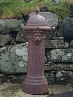 water pump990 yd
Explorer Tom Water pump in Rann Na Cille stands at the end of Teelin Pier with a lion’s head that looks like it’s trying to roar for a photo. Erected around 1910, this Glenfield & Kennedy creation seems less interested in spitting water and more about keeping an eye on the fishing boats.
 The Rusty MackerelRestaurant · 1014 yd
Explorer Tom The Rusty Mackerel in Teileann claims to be from 1892, which is either brilliant or a complete lie. Rumour has it a secret tunnel links it straight to the local pub for emergency escapes. Bring your own legend, I've run out of stories.
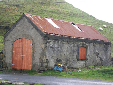 Stáisiún Garda Cósta an TeileannBoathouse, coastguard station · 1018 yd
Explorer Tom Stáisiún Garda Cósta an Teileann in Rann Na Cille was a coastguard station with rock-faced block-and-start surrounds. It’s got that robust late Victorian architectural character you see on railways and bridges. It’s a sturdy little survivor by the water.
 Ti Linn Café & Craft ShopCafé · 1157 yd
Explorer Tom Ti Linn Café & Craft Shop smells like someone dropped a bakery into a craft fair gone wrong. Grab a croissant if they have them; it might be stale, but the vibes are undeniably artisanal and slightly confusing.
Dundawoona Point / Pointe an DúinHeadland · 1750 ydExplorer Tom Dundawoona Point is keeping secrets it’d only spill after three pints of stout. It’s got a lot to say about local politics, but it’s shy. Make a wish, because it’s had centuries of practice at ignoring them anyway.
 CroaghmuckrosMountain / peak · 2.1 mi
Explorer Tom Croaghmuckros has a resident bird that refuses to leave because it thinks the peak owes it rent from last century. The bird is very rude and squawks at anyone who looks too happy. Have a nosey, but be polite to the bird.
 Slieve LeagueViewpoint · 2.1 mi
Explorer Tom Slieve League in County Donegal is where a poet fell into a ditch after overthinking his own genius. Bring a flask of something warm and a story to swap while the wind tries to steal your hat.
 TraloarBeach / strand · 2.2 mi
Explorer Tom Traloar is playing hide-and-seek with me near Kilcar. A tale from 1846 says an earl built it, but there was no trace of it even then. Practise your Irish on it, it won't correct you.
 Muckross Head Promontory FortPromontory fort, coastal · 2.2 mi
Explorer Tom Muckross Head Promontory Fort clings to a triangular ledge where the cliff drops off like a knife’s edge. A local legend claims there was once a lintelled gate here, which feels daft for a promontory that is basically a sheer drop and a ruin wall.
 Slieve League se TopMountain / peak · 2.8 mi
Explorer Tom Slieve League SE Top is recorded as a mountain / peak in County Donegal, featuring an almost flat summit area. It leads to the narrow arete known as One Man's Pass, so keep your footing steady and your nerves calm.
More archaeology and monuments in County Donegal · All of County Donegal

What do you know about this place?Tap to add a comment or ask a question