What is recorded here
Post-medieval C of I church possibly standing on site of medieval church (LI030-025006-) in the centre of a roughly rectangular-shaped graveyard (dims. 67m N-S; 64m E-W) enclosed by a stone wall of post-medieval date. Croom Castle (LI030-025005-) 140m to S, Croom Bridge 85m to E.
From the National Monuments Service (Archaeological Survey of Ireland) record LI030-025007
The monument record does not grant public access. Check the route and ask the landowner before entering private land.
- What survives
- Recorded monument
Places near here
Photo credits
- National Inventory of Architectural Heritage
- Willow, Wikimedia Commons · CC BY 2.5
- SteveODowd, Wikimedia Commons · CC BY-SA 4.0
- Mike Searle, Wikimedia Commons · CC BY-SA 2.0
- JohnArmagh, Wikimedia Commons · Public domain
- Callanmurphy, Wikimedia Commons · CC BY-SA 4.0
- John Baker, Geograph · CC BY-SA 2.0
- Colin Park, Geograph · CC BY-SA 2.0
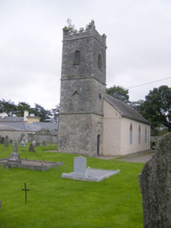 Saint Mary's Church (Croom)Church/chapel · 12 yd
 Saint Mary's Church (Croom)Mausoleum · 35 ydFont (present location) in CroomFont (present location) · 160 ydBiodiversity in the Maigue CatchmentVisitor information · 265 yd
 European ash1224 yd
 Dysert AenghusaHeritage attraction · 1.0 mi
_-_geograph.org.uk_-_6276354.jpg/250px-Castles_of_Munster,_Fanningstown,_Limerick_(1)_-_geograph.org.uk_-_6276354.jpg "Photo: Mike Searle, Wikimedia Commons · CC BY-SA 2.0") Fanningstown Castle (in ruins)Castle, tower house · 2.1 mi
Fanningstown Castle (in ruins)Castle, tower house · 2.1 mi Monasteranenagh AbbeyHeritage attraction · 2.4 miEuropean ash2.5 mi
 Franciscan AbbeyArchaeological place · 4.2 mi
 Desmonds Castle (in ruins)Castle, Anglo-Norman masonry castle · 4.4 mi
 KnockfeerinaMountain / peak · 4.8 mi
More archaeology and monuments in County Limerick · All of County Limerick
What do you know about this place?