
Places near here
Photo credits
- Wanfried-Dublin, Wikimedia Commons · CC BY-SA 4.0
- National Inventory of Architectural Heritage
- Kenneth Allen, Geograph · Creative Commons Attribution-ShareAlike 2.0
- Kenneth Allen, Geograph · CC BY-SA 2.0
- Rossographer, Geograph · CC BY-SA 2.0
- Vadim Manuylov, Wikimedia Commons · CC BY-SA 3.0
- Ronnie Nijboer, Wikimedia Commons · CC0
- VisionsofthePast, Wikimedia Commons · CC BY-SA 4.0
- Alan Reid, Geograph · CC BY-SA 2.0
- Michael Dibb, Wikimedia Commons · CC BY-SA 2.0
- Towel401, Wikimedia Commons · CC BY-SA 4.0
 Dermot and Granias Bed (1905).Portal tomb · 674 yd
Explorer Tom Take a look at Dermot and Granias Bed (1905), a portal tomb tucked into the garden of a house near Ballyness Bay. Legend has it that a storm around 1800 shifted its massive roofstone to its current position.
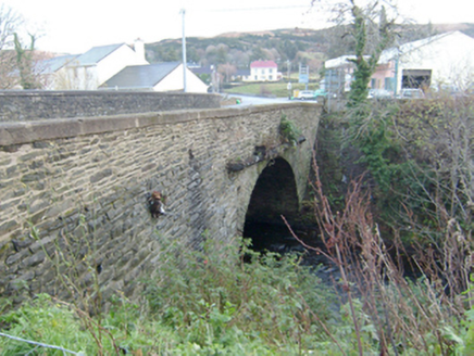 Droicheadh Bhedlam [Bedlam Bridge]Bridge · 894 yd
Explorer Tom Droicheadh Bhedlam [Bedlam Bridge] crosses the Glenna River on a single stone arch. The river sounds as though it is shouting at the bridge to calm down. What a name for such a polite arch!
 Teach Pobail Chríost Rí [Catholic Church of Christ the King]Church/chapel · 1048 yd
Explorer Tom Teach Pobail Chríost Rí is a Modernist church that Saint Patrick would probably say looks like a very confused box. It has a pitched double-height roof and flat aisles that create a geometric clash you can almost taste. The round-headed windows look like they’re winking at the square doors, so just enjoy the weirdness from afar.
 Ostan Loch AltanHotel · 1086 yd
Explorer Tom Ostan Loch Altan along the N56 pretends to be grand but looks like a haunted shed with delusions of grandeur. Grab me a warm drink before the ghosts start billing us for our stay there. Bring a map, get lost anyway, that's the fun.
 Maggie Dan'sRestaurant · 1128 yd
Explorer Tom Maggie Dan’s serves pizza, which is basically bread and cheese pretending to be Italian, and I bet the bargain that built it was a slice of regret. If it tastes like disappointment, grab a slice for me anyway because I’m too polite to complain in public. Bring a flask of something warm and a story to swap.
 MagheraroartyOfficial bathing water · 1.8 mi
Explorer Tom Magheraroarty has pulled a fine trick on the map: Atlantic on one side of a sandy spit, Ballyness Bay on the other, Inishbofin up north. That is enough directions for one beach to manage. The western shore takes a strong Atlantic wash, so I would keep my admiration on dry sand.
 Monterey Cypress2.6 mi
Explorer Tom Monterey Cypress in County Donegal is always getting picked on by the wind because it stands out like a sore thumb on the hillside. It’s trying to keep its cool, but you can tell it’s having a very rough day with all that gusting around. Tell it a joke, it's been a long time since anyone did.
 Wych Elm2.7 mi
Explorer Tom Wych Elm is writing a strongly worded letter to the council complaining about the noise from the new traffic lights nearby. It says it needs some quiet time to think about its roots, but really it just hates being woken up early. It’s got that grumpy neighbour vibe in full swing. If anyone asks, Tom sent you.
 Stone CrossCross, High cross · 3.5 mi
Explorer Tom Stone Cross at Ráith is a 5.56m giant that’s just been propped up on modern concrete. It used to lie broken in the graveyard, and locals once claimed it was smuggled from Tory Island, which feels like a proper stretch. Now it leans against the church wall, looking a bit like a tired grandfather who finally got some rest.
 Inis Bó FinneIsland · 3.8 mi
Explorer Tom Inis Bó Finne means island of the white cow, and I would offer to find her if the island did not have better things to show you. This is the Donegal Inishbofin off Magheraroarty, not the Galway one, covering about 120 hectares. Irish remains part of everyday speech. The population fell from 166 in 1911 to 16 in 2022, a change you should hold alongside the living community rather than treating the place as empty. Fishing and farming have shaped its ground, while smaller uninhabited islands sit nearby. I would promise to buy you a pint after the crossing, but there is no pub or shop to rescue that boast. Boats do run, yet there is no regular scheduled ferry; arrange travel and return in advance and respect homes and farmland. The island is small enough to cross, and far too real to treat as a backdrop.
 Cnoc FolaMountain / peak · 4.6 mi
Explorer Tom Cnoc Fola is the hill above the headland, with an old tale tying its name to Balor's blood. I picture a giant needing a very large handkerchief, though that belongs to legend, not my map. The map dot belongs on the hill.
 Oileán DúicheIslet · 4.8 mi
Explorer Tom Oileán Dúiche has a church ruin so small it is only fifteen feet long. The sole doorway stands five feet high but tapers as it rises, which is quite a fancy shape for such a tiny entrance. I reckon the builders really wanted to make sure you knew when you were getting in.
More historic places in County Donegal · All of County Donegal

What do you know about this place?Tap to add a comment or ask a question