What is recorded here
Chapel Russell became a parish only when Bishop Elrington chose it, though the name appears in 1418 and 1615. The Church of Ireland building stood in the old graveyard until demolition, leaving a bare rectangular platform and a broken corner wall beside mid-nineteenth-century headstones. A gold fibula surfaced nearby in 1834, hinting that the rocky ground had long gathered more than parish business.
On gently-undulating terrain. Ovoid area enclosed by stone wall (H 1.5m) with access via tree lined avenue to S. Church of Ireland church depicted on 1923 OS 6-inch map in NW quadrant has been demolished; sub-rectangular platform (8.8m N-S; 20.5m E-W) now visible with remains of |NW corner wall (1.05m N-S; 4.55m E-W; H 1.10m). Earliest headstones to S of church date from mid-nineteenth Century. No visible surface remains of earlier church known in the 15th century as Chapel Russell.
In 1840 the Ordnance Survey recorded the following; 'Of the old church of this parish not a vestige now remains. The modern church is situated in the North side of an old graveyard in the townland of Pallas on rocky ground' (OSL vol. 2, 6).
Westropp gives the following details on Pallaskenry also known as Chapel Russell; 'Formerly part of Killenalotar. "Cap. Russell spect. ad Com. Kildare," 1418; Capella Russell, 1615. It is, however, stated to have been only made a parish by Bishop Elrington. Site - Modern I. C. church on site; a gold fibula was found near it in 1834' (Westropp 1904-5, 387).
Compiled by: Denis Power
Revised by: Caimin O'Brien
Date of revised upload: 4 October 2018
The monument record does not grant public access. Check the route and ask the landowner before entering private land.
- What survives
- Recorded monument
Places near here
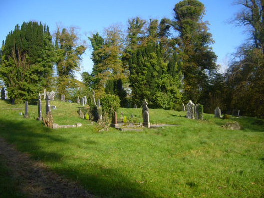 Pallaskenry Church (Chapelrussell)graveyard/cemetery · 4 yd
 Grave Yd.Graveyard · 18 yd
 Coláiste Sailíseachcountry house, church/chapel · 543 yd
 IndicatedEnclosure · 717 yd
 Shanpallas CastleCastle · 1162 yd
 Castle (in ruins)Castle, tower house · 1182 yd
 Sweet ChestnutSweet Chestnut · 1.2 mi
 Ringmoylan PierVisitor information · 2.0 mi
 Mellon PointHeadland · 2.2 mi
 Celtic Park and GardensHeritage attraction · 2.4 mi
 Rinekirk PointHeadland · 2.5 mi
 Stonehall Visitor FarmHeritage attraction · 2.5 mi