What is recorded here
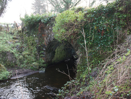
Single-arch bridge, c. 1860 and possibly containing fabric of earlier bridge to site c. 1800, carrying small road over small unnamed stream\former millrace flowing into the estuary of the River Leannan to the north. Segmental-headed arch having squared rock-faced voussoirs to arch; squared rubble stone construction to arch barrel with coursed and squared rock-faced masonry below arch springing point. Randomly coursed rubble stone construction to spandrels and to parapets. Modern repairs in places. Side elevations (north-east and south-west) now overgrown with ivy. Battered rubble stone abutment to east side having rock-faced squared stone quoins. Tarmacadam deck with grass verges. Located in the rural countryside to the south-east of Ramelton. Rubble stone wing walls to ends of parapets.
This simple but appealing small-scale bridge retains its early character and form, and is an appealing feature in countryside to the south-east of Ramelton. It is robustly-constructed in local rubble stone masonry, and its continued survival stands as testament to the quality of its original construction, and of the skill of the masons involved. This bridge is depicted on the Ordnance Survey first edition six-inch map of the area, c. 1834. However, the good-quality rock-faced voussoirs to the arches, and to the arch barrel below arch springing point, is a feature found at the many bridges that were built or altered by the Board of Works during the mid-to-late nineteenth century, and particularly between c. 1847-60, suggesting that this bridge may have been built or altered around this time. Located on a narrow road leading to Letterkenny, this small but robust bridge is an appealing landmark in a picturesque surrounding.
This does not grant access. Most recorded buildings are privately owned; view them only from public ground unless the owner allows entry.
Places near here
 Ramelton Old Masonic Lodgemasonic lodge/hall · 133 yd
 The Mansehouse · 170 yd
 Tullyaughnish Old Church GraveyardGraveyard · 235 yd
 Bawn in RathmeltonBawn · 432 yd
 European BeechEuropean Beech · 923 yd
 Drummonaghan WoodForest recreation place · 1522 yd
 Carnhill Stone Ringfort near the Ruined ChurchFairy fort / stone ringfort · 1.6 mi
 Ardnaree Raised Fairy FortFairy fort / earthen ringfort · 1.7 mi
 Fort Stewart in RuinsBawn · 2.9 mi
 Mullanadee ShoreBeach / strand · 4.9 mi
 Croaghan HillMountain / peak · 5.4 mi
 RathmullanOfficial bathing water · 6.1 mi
Other information
Photo: National Inventory of Architectural Heritage · Website use allowed for educational or private purposes with source credit