
What is recorded here
Two-arch bridge over river, extant 1760. WALLS: Part reconstructed rubble limestone walls with rubble limestone vertical coping to parapets. Pair of round arches with repointed voussoirs. SITE: Sited spanning Delvin River with unkempt banks to river. GENERAL: Occupies the site of an earlier bridge labelled as "The Naule Bridg" on the Down Survey (1656).
From the Buildings of Ireland (National Inventory of Architectural Heritage) record 11308003
This does not grant access. Most recorded buildings are privately owned; view them only from public ground unless the owner allows entry.
Places near here
Photo credits
- jwd, Geograph · CC BY-SA 2.0
- C O'Flanagan, Geograph · CC BY-SA 2.0
- Kieran Campbell, Geograph · CC BY-SA 2.0
- Zairon, Wikimedia Commons · CC BY 4.0
- SeoR, Wikimedia Commons · CC BY-SA 4.0
- Sitomon, Wikimedia Commons · CC BY-SA 2.0
 mill (water)86 yd
 church/chapel256 yd
 Seamus Ennis Cultural CentreMemorial · 300 yd
 Westown HouseCastle, tower house · 1102 yd
 Passage tomb in FourknocksPassage tomb · 1.5 mi
 Passage tomb art in FourknocksPassage tomb art · 1.5 mi
 KnockbrackMountain / peak · 1.8 mi
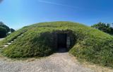 FourknocksPassage tomb · 2.0 mi
 Hollywood GreatMountain / peak · 2.4 mi
 Gormanston CastleCastle · 3.9 mi
 European Yew3.9 miEuropean Yew3.9 mi
More historic places in County Dublin · All of County Dublin
What do you know about this place?