
What is recorded here
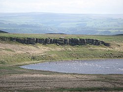
Natural "Rock Art" is an ancient stone or rock art in Northumberland, England.
From the Geograph Britain and Ireland picture record 4757939
The picture record does not grant public access. Use signed public paths and do not enter private land without permission.
Places near here
Photo credits
- Karl and Ali, Wikimedia Commons · CC BY-SA 2.0
- Andrew Curtis, Wikimedia Commons · CC BY-SA 2.0
- Les Hull, Wikimedia Commons · CC BY-SA 2.0
- John Poyser, Wikimedia Commons · CC BY-SA 2.0
- Ray Barnes, Wikimedia Commons · CC BY-SA 2.0
- Mike Quinn, Wikimedia Commons · CC BY-SA 2.0
- Rudi Winter, Wikimedia Commons · CC BY-SA 2.0
- Oliver Dixon, Wikimedia Commons · CC BY-SA 2.0
- Fryslan0109 at en.wikipedia, Wikimedia Commons · Public domain
- David Dixon, Wikimedia Commons · CC BY-SA 2.0
 Jingling WellSpring · 318 yd
 Nanny's HillMountain / peak · 592 yd
 Small Waterfall on Jenkins BurnWaterfall · 881 yd
 Roman quarry inscription on Queen's Crags, 680m south east of East HotbankScheduled monument · 982 yd
 Animal House to Rear of East Stonefolds FarmhouseListed building · 1004 yd
 Queen's CragCliff · 1011 yd
 'Ridley Common' Stone CircleAncient stone or rock art · 1075 yd
 Dove CragCliff · 1175 yd
 Clew HillMountain / peak · 1504 yd
 Knag Burn GatewayRuins · 1520 yd
 VercoviciumFort · 1642 yd
 Housesteads MuseumMuseum · 1.0 mi
More archaeology and monuments in Northumberland · All of Northumberland
What do you know about this place?