Places near here
Photo credits
- Keith Cunneen, Geograph · CC BY-SA 2.0
- JohnArmagh, Wikimedia Commons · CC BY-SA 3.0
- National Inventory of Architectural Heritage
- Nigel Cox, Geograph · CC BY-SA 2.0
- Nigel Thompson, Wikimedia Commons · CC BY-SA 2.0
- Garry Dickinson, Geograph · CC BY-SA 2.0
- Eileen Henderson, Geograph · CC BY-SA 2.0
- DavidBosonnet, Wikimedia Commons · CC BY-SA 4.0
- Jonathan Thacker, Geograph · CC BY-SA 2.0
- Phil Champion, Geograph · CC BY-SA 2.0
- Rossographer, Geograph · CC BY-SA 2.0
 Eagles HillMountain / peak · 1.5 mi
Explorer Tom Eagles Hill has a hidden treasure buried under the ridge that is definitely just an old biscuit tin filled with rust, but locals swear it holds ancient gold. They refuse to dig because they’re too scared of what might be inside, which is probably nothing. Find a local and ask them the real story, then come back and tell me.
 Church IslandEcclesiastical site · 2.6 mi
Explorer Tom Church Island hides a treasure that’s definitely a biscuit tin left by a bored monk in the sixth century. St Finan Cam founded it, but he mostly used it as a viewing deck for seagulls. Perfect spot to practise your best tour-guide voice.
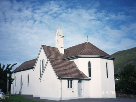 Saint Crohan's Catholic ChurchChurch/chapel · 2.7 mi
Explorer Tom Saint Crohan's Catholic Church in Ballycarnahan hears the neighbours arguing about football through its thick stone walls. It just sits there judging them silently from the bellcote. A handy spot to stretch your legs and your imagination.
 CaherdanielFairy fort / stone ringfort · 2.7 mi
Explorer Tom Caherdaniel had a fox take charge of the whole operation back in the day. It wore a tiny hat and barked orders at the builders until they finished the walls. Bring a coin for luck and keep it in your pocket.
 Caherdaniel Stone FortVisitor attraction · 2.7 mi
Explorer Tom Caherdaniel Stone Fort in Kerry has confused map makers so badly they gave up and started guessing. The name is long enough to make your head spin before you even get there. Go before the tourists find out.
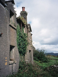 coastguard station2.7 mi
Explorer Tom Coastguard station in Coad has a long grudge against the weather for ruining its ruins. It was once a sanatorium, which makes the damp feel even more personal. Look up, the best bit is always higher than you think.
 Castle Cove (in Ruins)Castle, tower house · 3.0 mi
Explorer Tom Castle Cove is built on a rock outcrop where O'Sullivan Mores and Brennans both claim credit, so the seagulls probably just laugh at them for fighting over such a small patch of stone. It has a spiral stair in the corner and a latrine chute that makes modern plumbing look like a luxury you can do without. Go on, count the windows and get it wrong like I did.
 Ogham StoneVisitor information · 3.3 mi
Explorer Tom Ogham Stone stands there near Derrynane House, covered in ancient scratches that locals swear will turn your hair green if you don't wave politely before leaving. I’ve never waved at a stone, so my hair is still brown, which proves the superstition is complete nonsense or I have very lucky follicles. A proper spot for a flask of tea and a big think.
 Derrynane House / Teach Dhoire FhionáinHeritage attraction · 3.5 mi
Explorer Tom Derrynane House has a superstition that locals swear by: if you touch the wall three times, your luck improves slightly but your shoes get muddy. It’s grand, but it definitely thinks it’s better than everyone else in the county. Sit on a wall near it and pretend you're in a painting.
 Waterville PromenadeWalking route · 3.7 mi
Explorer Tom Waterville Promenade handles nosey neighbours by simply shifting its stones so they can't find their way back to the beach. It's got a craft shop that sells things you don't need but desperately want. Spot the oldest stone and give it a name.
 White StrandBeach / strand · 3.8 mi
Explorer Tom White Strand near Castlecove hides a tunnel to the pub, according to one very tall tale. The locals say it only opens when the tide is low and your wallet is empty. It’s a classic Irish myth that refuses to die. If it's closed, admire it from the road like a polite stalker.
 Derrynane Beach / Trá Doire FhíonáinBeach / strand · 3.8 mi
Explorer Tom Derrynane Beach in County Kerry would say 'I have excellent teamwork skills' in a job interview. It basically holds up the whole coastline while everyone else takes selfies. Bring a notebook and write the bit I made up.
More mountains and hills in County Kerry · All of County Kerry

What do you know about this place?Tap to add a comment or ask a question