What is recorded here
Places near here
Photo credits
- National Inventory of Architectural Heritage
- Maker not stated on source page, commons.wikimedia.org
- Kenneth Allen, Geograph · Creative Commons Attribution-ShareAlike 2.0
- Maker not stated on source page, www.alamy.com
- Kenneth Allen, Geograph · CC BY-SA 2.0
- Simonchadwick1023, Wikimedia Commons · CC BY-SA 4.0
- Andreas F. Borchert, Wikimedia Commons · CC BY-SA 4.0
 Saint Tighernach's National SchoolSchool · 636 yd
Explorer Tom Saint Tighernach's National School in Largy gave up chocolate for Lent but kept its timber sash windows because those…
 Sacred Heart CemeteryCemetery · 650 yd
Explorer Tom Sacred Heart Cemetery in County Monaghan has a secret it would tell after a few pints, probably about who actually…
 post box655 yd
Explorer Tom Post box in Largy is an early surviving artifact of mass-produced cast-iron, standing on Church Hill like a little iron…
 Catholic Church of the Sacred HeartChurch/chapel · 677 yd
Explorer Tom Catholic Church of the Sacred Heart in Largy is standing tall on its hill like it’s ready to lead a very fancy choir…
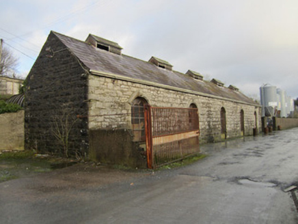 store/warehouse744 yd
Explorer Tom This Store in Largy is a railway goods shed that’s just waiting for the trains to come back. It does weird things when…
 Saint Joseph's Temperance HallHall · 796 yd
Explorer Tom Saint Joseph’s Temperance Hall wants 'No Regrets' on its tombstone because it gave up on alcohol early. It’s sitting…
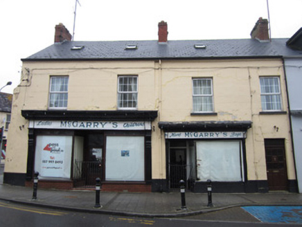 McGarry'sShop/retail outlet · 924 yd
Explorer Tom McGarry’s shop in Crossmoyle had an escape plan involving a goat cart, which explains the weird window arrangement.…
 Fairy fort / earthen ringfort in Altartate GlebeFairy fort / earthen ringfort · 996 yd
Explorer Tom Fairy fort / earthen ringfort in Altartate Glebe was destroyed by a railway cutting, which is just lazy planning if you…
 Mapped graveyardGraveyard · 1137 yd
Explorer Tom this Mapped graveyard in County Monaghan has an imaginary twin across the sea that sends it postcards every Christmas…
 The Cassandra Hand CentreMuseum · 1269 yd
Explorer Tom Cassandra Hand's name sits on a little Gothic schoolhouse in Clones, and it sounds as though she might demand your…
 Abbey RuinsHeritage attraction · 1271 yd
Explorer Tom The map calls this little Clones ruin “Abbey Ruins”, which is technically fair and about as thrilling as calling a…
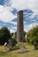 Round Tower1334 yd
Explorer Tom Round Tower in Crossmoyle stands there looking all serious, built back when people liked their architecture simple and…
More memorials and graveyards in County Monaghan · All of County Monaghan

What do you know about this place?Tap to add a comment or ask a question