
What is recorded here
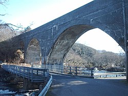
Morar, Road Bridge Over River Morar is a road bridge in Highland, Scotland.
From the Historic Environment Scotland record 290980
The historic-place record does not grant public access. Check current conditions and ownership before entering land or a building.
Places near here
Photo credits
- Lynn M Reid, Wikimedia Commons · CC BY-SA 2.0
- Gordon Hatton, Wikimedia Commons · CC BY-SA 2.0
- Lynne Kirton, Wikimedia Commons · CC BY-SA 2.0
- David Dixon, Wikimedia Commons · CC BY-SA 2.0
- Stephen McKay, Wikimedia Commons · CC BY-SA 2.0
- Jackie Proven, Wikimedia Commons · CC BY-SA 2.0
- Rob Patterson, Wikimedia Commons · CC BY-SA 2.0
- Dave Fergusson, Wikimedia Commons · CC BY-SA 2.0
- Richard Webb, Wikimedia Commons · CC BY-SA 2.0
- Jennifer Jones, Wikimedia Commons · CC BY-SA 2.0
- John Myers, Wikimedia Commons · CC BY-SA 2.0
 Morar, Falls of Morar ViaductRailway Viaduct (19th Century) · 23 yd
 Falls of MorarWaterfall · 205 yd
 Battle of MorarBattle · 454 yd
 MorarEnclosure · 618 yd
 Morar, Roman Catholic Church of St Cumin and PresbyteryChurch (late 19th Century) (1889), Presbytery (late 19th Century) · 813 yd
 Morar BayCave(s) · 1635 yd
 Eilean BànWood · 1.0 mi
 Bun an LòinBay · 1.1 mi
 An t-Eilean MeadhoinWood · 1.4 mi
 Tòrr na BàMountain / peak · 1.5 mi
 Traigh HouseNo Class (event) (21st Century) · 1.9 mi
 Glasnacardoch BayBay · 2.3 mi
More historic places in Highland · All of Highland
What do you know about this place?