
What is recorded here
Monument, St Michael, Sandhurst is a monument or public art in Bracknell Forest, England.
From the Geograph Britain and Ireland picture record 3883716
The picture record does not grant access. Use signed public paths and do not enter private land without permission.
Places near here
 School HillMountain / peak · 671 yd
 Ambarrow CourtNature reserve · 747 yd
.jpg/250px-Ancient_well_on_Scotland_Hill_at_night_(geograph_7442792).jpg "Photo: Oscar Taylor, Wikimedia Commons · CC BY-SA 2.0") Ancient WellListed building · 771 yd
Ancient WellListed building · 771 yd Treacle Mines of Cock-a-DobbyArchaeological place · 810 yd
 Horseshoe LakeNature reserve · 929 yd
 Ambarrow HillMountain / peak · 1113 yd
 Yateley fire stationHeritage place · 1237 yd
 Darby Green Playing FieldsVisitor information · 1.1 mi
 Horseshoe Lake & Moor Green Lakes Nature ReserveVisitor information · 1.2 mi
 Old Milestone by the A30, Yateley CommonMonument or public art · 1.7 mi
 Angel statue, BroadmoorMonument or public art · 2.1 mi
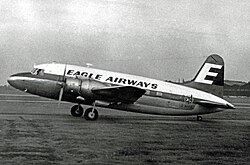 1957 Blackbushe Viking accidentAviation accident · 3.2 mi
Pictures: Oscar Taylor, Wikimedia Commons · CC BY-SA 2.0; Diane Sambrook, Wikimedia Commons · CC BY-SA 2.0; Len Williams, Wikimedia Commons · CC BY-SA 2.0; Kevin Hale, Wikimedia Commons · CC BY-SA 2.0; Alan Hunt, Wikimedia Commons · CC BY-SA 2.0; Colin Smith, Wikimedia Commons · CC BY-SA 2.0; Rob Agar, Wikimedia Commons · CC BY-SA 2.0; RuthAS, Wikimedia Commons · CC BY 3.0
More archaeology and monuments in Bracknell Forest · All of Bracknell Forest
What do you know about this place?