What is recorded here
Monreith, Cross is a cross in Dumfries and Galloway, Scotland.
From the Historic Environment Scotland record 62773
The historic-place record does not grant public access. Check current conditions and ownership before entering land or a building.
Places near here
Photo credits
- Ann Cook, Wikimedia Commons · CC BY-SA 2.0
- Andy Farrington, Wikimedia Commons · CC BY-SA 2.0
- David Medcalf, Wikimedia Commons · CC BY-SA 2.0
- David Baird, Wikimedia Commons · CC BY-SA 2.0
- Billy McCrorie, Wikimedia Commons · CC BY-SA 2.0
- Chris Newman, Wikimedia Commons · CC BY-SA 2.0
- Jon Alexander, Wikimedia Commons · CC BY-SA 2.0
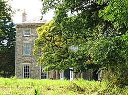 Monreith HouseCountry House (18th Century) · 22 yd
 White Loch of MyrtonCrannog · 520 yd
 Monreith, West Gate LodgeGate Lodge (19th Century) · 668 yd
 Monreith House, Bridge LodgeLodge · 1095 yd
 Court Hill PlantationForest · 1.2 mi
 Margarets: Port William Harbour Entrance, Luce Bay, Solway FirthSchooner (19th Century) · 1.3 mi
 Mary: Port William Harbour Entrance, Luce Bay, Solway FirthSloop (19th Century) · 1.3 mi
 Old Place of MonreithTower House (medieval) · 1.6 mi
 Ravenstone CastleCountry House (19th Century), Tower House (16th Century) · 3.4 mi
 Fell of CarletonMountain / peak · 4.2 mi
 pen HillMountain / peak · 4.4 mi
 Cairn PlantationWood · 4.5 mi
More archaeology and monuments in Dumfries and Galloway · All of Dumfries and Galloway
What do you know about this place?