What is recorded here
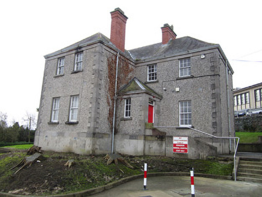
Monaghan County Hospital in Mullaghmonaghan looks modest from the front, then keeps producing wings and additions behind it. It’s the building equivalent of your aunt saying there’ll be ‘just ourselves’ for dinner while borrowing forty chairs.
Detached T-plan two-storey house built c.1930, having five-bay front elevation, two bays projecting forward, porch to re-entrant corner, and having two-bay single-storey wing to south-east with two single-storey additions to rear. Hipped slate roofs to main block and to wing, with red brick chimneystacks having stone copings, terracotta ridge tiles, and replacement rainwater goods. Flat roofs to rear additions. Roughcast rendered walls with ashlar limestone to porch and to quoins, and with cut-stone eaves and plinth courses. Square-headed window openings, with timber sliding sash windows, six-over-six pane to northern bays of front elevation and projection, four-over-four pane to south bay and south elevation, and varied six-over-six, double four-over-four pane, and timber casement windows to rear, all with patent rendered reveals and stone sills. Stairs window to rear has stained glass, as does window to side wall of porch. Square-headed opening to porch with chamfered limestone surround, timber panelled door, overlight and approached by flight of concrete steps with concrete parapet wall. Set in grounds of Monaghan General Hospital and bounded by rendered walls having stepped-plan rendered piers, with metal railings.
Its L-plan distinguishes the form of this deceptively large hospital building. The cut limestone quoins and the tall red brick chimneystacks add interest and textural contrast to an otherwise plain facade. The retention of timber joinery to windows and doors adds to the architectural heritage interest and value of the structure.
From the Buildings of Ireland (National Inventory of Architectural Heritage) record 41303080
This does not grant access. Most recorded buildings are privately owned; view them only from public ground unless the owner allows entry.
Places near here
Photo credits
- National Inventory of Architectural Heritage
- Kenneth Allen, Geograph · CC BY-SA 2.0
- Eric Jones, Geograph · Creative Commons Attribution-ShareAlike 2.0
- Eric Jones, Geograph · CC BY-SA 2.0
- Raymond Okonski, Wikimedia Commons · CC BY-SA 2.0
- Andreas F. Borchert, Wikimedia Commons · CC BY-SA 3.0 de
- Brian Lenehan, Geograph · CC BY-SA 2.0
- Willow, Wikimedia Commons · CC BY 2.5
- Walking with a phone, Wikimedia Commons · CC BY-SA 4.0
 bank/financial institution71 yd
 bank/financial institution110 yd
 bank/financial institution116 yd
 Laurel LodgeHouse · 123 yd
 Johnston and Madden Memorial Orange HallOfficially recorded historic building · 125 yd
 Holly LodgeGates/railings/walls · 132 yd
 Dawson MonumentMonument · 264 yd
 Rossmore MonumentMemorial · 347 yd
 Monaghan County MuseumMuseum · 534 yd
 Old Cross SquareMonument · 608 yd
 European ash995 yd
 Rossmore MausoleumHeritage attraction · 2.4 mi
More historic places in County Monaghan · All of County Monaghan
What do you know about this place?