What is recorded here
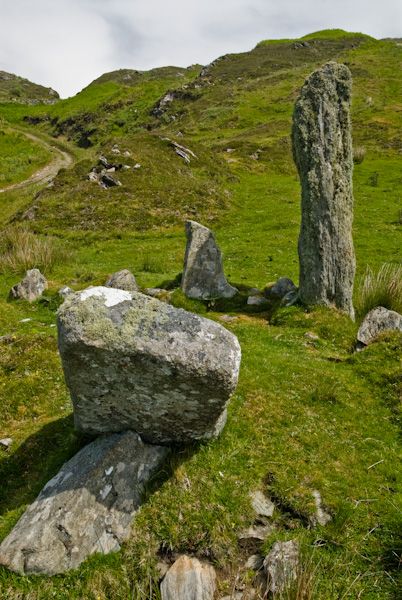
Mon. Pillar is a 1.75m ogham stone at Templemanaghan, County Kerry, traditionally marked as the grave of St. Manchan. It stands on the lower eastern slopes of Lateevemore, overlooking Dingle Harbour and the Milltown valley. The NE angle bears an ogham inscription naming QENILOCI MAQI MAQI-AINIA MUC, while the E face carries a plain equal-armed cross and the W face a cross with an expanded upper arm. A notch on the N angle may have been a circular hole. The stone is National Monument No. 62 and has been studied in the Ogham in 3D project.
National Monument No. 62. Templemanaghan/Teampall Mhanacháin or Teampall Geal and its associated burial ground lie on the lower E slopes of Lateevemore and command a magnificent view over Dingle Harbour and the Milltown valley.
Ogham stone (KE043-140008-) Fig. 148: Traditionally regarded as marking the grave of St. Manchan, this stone stands c. 1.75m high and is .56m wide at base. The ogham inscrits NE angle reads: QENILOCI MAQI MAQI-AINIA MUC(.... There is no trace whatsoever of the inscription in half uncial script which Macalister (1945, 163-4) noted beside the ogham inscription and which, according to him, read: FECT QUENILOC. The E face of the stone bears a plain equal-armed cross. A roughly equal-armed cross on the W face has an expanded terminal to its upper arm. A notch on the N angle of the stone may formerly have been a circular hole.
The above description is derived from J. Cuppage, ‘Corca Dhuibhne. Dingle Peninsula archaeological survey. Ballyferriter. Oidhreacht Chorca Dhuibhne’ (1986), no. 824.
See attached photograph courtesy of Amanda Clarke
This stone has been studied as part of the ‘Ogham in 3D’ project undertaken by the School of Celtic Studies, Dublin Institute for Advanced Studies. To access details go to the following website: http://ogham.celt.dias.ie/search.php?ciic=170
Updated by: Paul Walsh
Revised date of upload: 2 January 2015
This remains an important historical record, but the official description says the monument is no longer visible or has been destroyed. The monument record does not grant public access. Check the route and ask the landowner before entering private land.
- What survives
- No visible remains or recorded as destroyed
Places near here
 Templemanaghan (Oratory)Church · 19 yd
 PoulnasaggartMan-made underground passage · 29 yd
 TobermanaghanHoly well · 188 yd
 Binn BreacMountain / peak · 922 yd
 Church in Cill FhiontainChurch · 1.1 mi
 An Chathair AirdMountain / peak · 1.2 mi
 Gallarus OratoryHeritage attraction · 1.5 mi
 Gallarus CastleCastle · 1.8 mi
 Gallarus Castle (in ruins)Castle, tower house · 1.8 mi
 Dingle Marina Dive CentreHeritage attraction · 2.5 mi
 Charles HaugheyMemorial · 2.6 mi
 Memorial to all who lost their lives in our seas.Memorial · 2.6 mi