
What is recorded here
From the National Monuments Service (Archaeological Survey of Ireland) record WI037-008
Places near here
Photo credits
- Maker not stated on source page, commons.wikimedia.org
- liam murphy, Wikimedia Commons · CC BY-SA 2.0
- Maker not stated on source page, turtlebunbury.com
- Maker not stated on source page, ar.pinterest.com
- Maker not stated on source page, www.flickr.com
- Simon Dowling, Wikimedia Commons · CC BY-SA 4.0
- Maker not stated on source page, www.dreamstime.com
- Malene Thyssen, Wikimedia Commons · CC BY-SA 3.0
- Christian Pirkl, Wikimedia Commons · CC BY-SA 3.0 at
- Maker not stated on source page, carlowtourism.com
 Ogham stone in Glebe (rathvilly By.)Ogham stone · 821 yd
Explorer Tom Ogham stone in Glebe is a lost stone that had a New Year's resolution to stop moving and just stay put for once. It was…
 Saint Mary's Catholic ChurchChurch/chapel · 1018 yd
Explorer Tom Saint Mary's in Ballyconnell has been holding onto its pre-Vatican II vibe since 1873 while everyone else is busy…
 Church in KnockballystineChurch · 1275 yd
Explorer Tom Church in Knockballystine is marked as a chapel site on the map, but there are no visible traces. It’s a bit like a shy…
 Crecrin ChurchRuins · 1431 yd
Explorer Tom Crecrin Church is famous for a giant who used to live there and ate all the local bread before hiding under the…
 Crecrin GraveyardGraveyard · 1435 yd
Explorer Tom Crecrin Graveyard claims to be older than the hills around it, which is a stretch even for a local legend. It’s been…
 Enclosure in KnockeenEnclosure · 1.2 mi
Explorer Tom Enclosure in Knockeen claims it survived a storm so bad it made the clouds cry, though I suspect it just hid under a…
 Standing stone in LiscolmanStanding stone · 1.2 mi
Explorer Tom Standing stone in Liscolman is strutting on that ridge like it owns the hill. It’s got crop-mark friends nearby but…
 Rathgall, HachuredHillfort · 1.5 mi
Explorer Tom Rathgall holds a deep secret about which side of its four concentric rings was built by actual people versus giant…
 Aghold GraveyardGraveyard · 3.0 mi
Explorer Tom Aghold Graveyard has a local legend about a poet who fell into the ditch nearby and wrote his masterpiece while soaking…
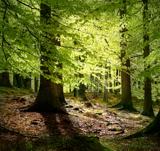 European Beech3.6 mi
Explorer Tom European Beech in County Wicklow was prophesied to become a giant disco ball but sadly the budget ran out before the…
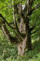 Sycamore3.6 mi
Explorer Tom Sycamore in County Wicklow is bragging about surviving a storm that probably only had a light drizzle, acting like it…
 CastleCastle, unclassified · 4.7 mi
Explorer Tom Castle in Craans, Carlow, would describe itself to a stranger as 'elusive.' It’s on the map but its exact location is a…
More archaeology and monuments in County Wicklow · All of County Wicklow

What do you know about this place?Tap to add a comment or ask a question