DDiscover AloneMapAbout

Moat in Westown

Barrow, stepped barrow

The monument record does not grant public access. Check the route and ask the landowner before entering private land.

What survives
Recorded monument
What do you know about this place?Tap to add a comment or ask a question

What you write will be public.

What is recorded here

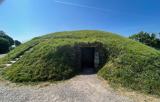
This barrow is situated on a hilltop under pasture beside the Naul to Fourknocks road and near the Ford of Fyne. A circular dome-shaped mound (diam. 15m; H 2.5m) which rests on a circular earthen platform (diam.30m; H2m). (Healy 1975, 16; Scully 1972-3, 103). Slopes down steeply to north and south to circular…

Read the whole record
This barrow is situated on a hilltop under pasture beside the Naul to Fourknocks road and near the Ford of Fyne. A circular dome-shaped mound (diam. 15m; H 2.5m) which rests on a circular earthen platform (diam.30m; H2m). (Healy 1975, 16; Scully 1972-3, 103). Slopes down steeply to north and south to circular tree-lined enclosure. marked on the OS 25" as a 'moat'. Directly to the north on the other side of the Delvin is the Fourknocks ridge. When the grass is down large stones are visible. The monument was recently surveyed by Trim Archaeology Projects Ltd., the results of which were summarised as follows; 'The monument site was enclosed by a ring of trees which formed a small plantation in a former designed landscape of Westown Demesne. Today there are trees along the boundary to the SW and there are hedgerows forming boundaries from the SE around to the north of the monument with occasional large trees along them. It is adjacent to a former Gate lodge and avenue to Westown House, constructed c.1890. A garden centre now occupies the adjacent site which is attached to the gate lodge. The monument appears to be composed of an upper mound and lower mound. The lower mound measures 23.8m in diameter and its height is 1.2m. It’s lower break of slope is recorded at 85.7m OD, while the upper break of slope measures 86.9m OD. The upper mound is located in the centre of the lower mound. It measures 10m in diameter and 1m in height. It’s shape is more bulbous than the lower mound. The lower break of slope of this mound is at 87.5 OD and the top of the mound at 89.2m OD, so the mound itself is 1.3m high. The total height of the monument is 2.5m. On top of the upper mound, two distinct features were identified in the survey. One is a circular feature measuring 4m in diameter and 0.2m in height situated just off centre on the mound. There is a dip in the centre suggesting that this upper mound may have had a shallow bank or rise on its outer edge, either an original feature or a later addition. The second feature identified is located in the centre of the first. It measures 0.5m in width and 0.2m in height and while it may be of archaeological interest, it could also be related to vegetation growth. There was no depression recorded in this mound, which, if present might have represented earlier antiquarian investigations. It is unlikely therefore, that the site was ever excavated or disturbed in the modern period. The profile of the barrow at Moat Wood appears to closely resemble the campanile form, with a distinct bulbous, flat-topped central mound form with a flaring berm and bevelled skirt around the bottom. When compared to other stepped barrows in Ireland, the distinct form of the barrow at Moat Wood would appear to better resemble the architectural characteristics of the stepped barrow’s UK counterpart, the ‘bell’ barrow, which is a more definitive morphology than that seen under the broader stepped barrow classification. Between July 25th and August 4th and the 25th and 26th August 2022, a series of geophysical surveys were undertaken over Barrow DU004-005 and on lands surrounding the monument by Earthsound Geophysics Ltd. The electromagnetic investigations of the land surrounding recorded monument barrow DU004-005---- revealed a series of relict agricultural boundaries and what may be associated cultivation furrows. The orientation of these is different than the field boundaries now, but the earliest mapping which shows field boundaries, Rocque’s map seems to indicate a similar pattern to the present, so this system is likely earlier than the 18th century. The land surrounding the recorded monument was subjected to a series of high-resolution surveys consisting of high resolution topographical and earth resistance surveys as well as lines of electric resistivity tomography and ground penetrating radar. These surveys revealed the full extent and composition of the monument. Two distinct mounds were identified. The lower mound measures c.23.8m in diameter and 1.2m in height, has a relatively flat top and is surrounded by a possible enclosure ditch and agricultural features. The upper mound has been placed on the centre of the lower and measures 10m in diameter and over 1m in height. This mound is more bulbous in formation and has no distinctive break in slope at the top. A circular expression measuring c. 4m in diameter and 0.2m in height sits on top of the upper mound. A central topographical expression measuring c.0.5 wide and 02m in height sits on top of this circular expression. The internal structure of both mounds indicates that they appear to be built on the natural topography and contain multiple separate deposition events, it was impossible to tell if they represent one building event or are two mounds built at separate times one on top of another. Surrounding this mound, a possible enclosure ditch was detected as well as evidence for agricultural processes. Adjacent to the mounds evidence for arcing ditches, pits, stone deposits and banks was detected. While some of these appear to follow or respect the alignment of the mounds and are suggestive of archaeological remains others represent agricultural boundaries' (Carroll 2022; Gimson 2022). See attached Drone photographs courtesy of Ian Lennon. Carroll, F. 2022 Conservation Study & Management Plan 2022, Moat Wood, Westown (Naul) Co. Dublin. Unpublished report by Trim Archaeology Projects Ltd. on behalf of Naul Community Council funded by the Community Monuments Fund. Gimson, H. 2022 Investigation of Barrow DU004-005- and surrounding lands, Westown, Naul, Co. Dublin Archaeological Geophysical Survey Detection Licence No. 22R0226. Unpublished report by Earthsound Geophysics on behalf of Naul Community Council funded by the Community Monuments Fund.

From the National Monuments Service (Archaeological Survey of Ireland) record DU004-005

Places near here

Picture notes
  • Computer-made picture. It does not show this monument.
  • C O'Flanagan, Geograph · CC BY-SA 2.0
  • Offdaw, Wikimedia Commons · CC BY-SA 4.0
  • jwd, Geograph · CC BY-SA 2.0
  • Computer-made picture. It does not show this garden.
  • Kieran Campbell, Geograph · CC BY-SA 2.0
  • SeoR, Wikimedia Commons · CC BY-SA 4.0
Enclosure in WestownEnclosure · 357 ydTom: I’m here to help · Computer-made picture. It does not show this monument.

Explorer Tom Westown’s enclosure is hiding under corn on a ridge, guarding a treasure that’s definitely a biscuit tin. It radiates field systems like a very confused sunflower. Get there early and have it all to yourself before the cows notice the secret.

Ford of FineFord · 507 ydTom: I’m here to help · Computer-made picture. It does not show this monument.

Explorer Tom The Ford of Fine is where you cross the river like a hero or a fool, depending on your shoes. It’s been on maps since before we had proper trousers, so respect that. Pretend you're a lost aristocrat, nobody will check.

Westown HouseCastle, tower house · 753 yd

Explorer Tom Westown House in Westown is an 18th-century mansion that swallowed a medieval tower house whole like a very posh snack. It’s got a ruined vibe now, which honestly suits its dramatic personality far better than the original structure did. Bring a camera and your most suspicious face.

Catholic Church of the Nativity of Our LadyChurch/chapel · 1313 yd

Explorer Tom Catholic Church of the Nativity of Our Lady in Westown is shaped like a T, which is weird for a church. Dated 1821, it’s got obelisk pinnacles on the corners. Look cool while you photograph it!

Naul Park HouseCastle, unclassified · 1343 yd

Explorer Tom Naul Park House has caught my eye in Naul, County Meath. I bet a castle, unclassified with a name like that could keep me talking all afternoon; I'm already inventing a daft little scene for it, and I'll stop before it turns into history.

mill (water)1403 yd

Explorer Tom A water mill in Westown built in 1720 that has been in ruins since 1934, which is a long time to be messy. The wind keeps picking on it because it’s jealous the river gets all the attention. Pop by and tell it it's looking well, even if it’s just rubble now.

Fingal AllotmentsGarden · 1423 ydTom: I’m here to help · Computer-made picture. It does not show this garden.

Explorer Tom Fingal Allotments in County Dublin are probably where Fingal grows his vegetables. No accounts mean he might still be there, tending to his potatoes. Check if any cabbages look angry. If so, apologize for the lack of sunlight.

NaulMemorial · 1433 yd

Explorer Tom Naul in County Dublin is a memorial, but there's also a bar called Killian's Bar nearby. I bet people go to the bar after remembering something important. Find the bar and ask the bartender what exactly we're remembering here today.

Seamus Ennis Cultural CentreMemorial · 1463 yd

Explorer Tom The Seamus Ennis Cultural Centre in County Dublin opened in 2001 to celebrate a piper who knew his stuff. I bet the music inside is loud. Go get some tunes for me!

FourknocksPassage tomb · 1.7 mi

Explorer Tom Fourknocks has caught my eye in County Meath. I bet a passage tomb with a name like that could keep me talking all afternoon; I'm already inventing a daft little scene for it, and I'll stop before it turns into history.

KnockbrackMountain / peak · 2.1 mi

Explorer Tom Knockbrack has a trig station on top for handy navigation. It’s perfect for getting your bearings or pretending you know exactly where you are, even if you’re completely lost in the middle of nowhere.

Hollywood GreatMountain / peak · 2.4 mi

Explorer Tom Hollywood Great overlooks a church graveyard and Lambay Island in the distance. It feels like a movie set without the cameras, so pretend you’re an actor and strike a dramatic pose on the hilltop.

More archaeology and monuments in County Dublin · All of County Dublin

Add to this placeAdd a picture Add a detailed tip Add a story

Explore the map1,087,615 places to discover

Next place · or swipeEnclosure in Westown