
What is recorded here
From the National Monuments Service (Archaeological Survey of Ireland) record CO138-001001
Places near here
Photo credits
- Maker not stated on source page, www.dreamstime.com
- Maker not stated on source page, commons.wikimedia.org
- Richard Webb, Wikimedia Commons · CC BY-SA 2.0
- Gordon Hatton, Geograph · CC BY-SA 2.0
- Colin Park, Geograph · CC BY-SA 2.0
- Gerd Eichmann, Wikimedia Commons · CC BY-SA 4.0
- National Inventory of Architectural Heritage
- Maker not stated on source page, au.pinterest.com
- Towel401, Wikimedia Commons · CC BY-SA 4.0
 Holed stone in CaherurlaghHoled stone · 1.1 mi
Explorer Tom Holed stone in Caherurlagh is fallen down but has a circular hole for healing. I’d put my back through there if it…
 Fairy fort / earthen ringfort in Letter EastFairy fort / earthen ringfort · 1.4 mi
Explorer Tom Fairy fort / earthen ringfort in Letter East has stone facing in parts, which makes it look like it tried to dress up…
 Standing stone in Caher (carbery W. (w.d.) By., Kilcrohane Par.)Standing stone · 1.8 mi
Explorer Tom Standing stone in Caher is playing hard to get. Roberts said he found one, but nobody else has spotted it since. It's…
 Caher MountainMountain / peak · 1.9 mi
Explorer Tom Caher Mountain is hiding a scandal involving a lost sheep that became a local legend and still causes chaos. It's 317…
 Peakeen Ridge Loop WalkWalking route · 2.1 mi
Explorer Tom Peakeen Ridge Loop Walk hears the neighbours gossiping through the stone walls every single night without fail. They…
 Ballyroon Mountain Signal TowerRuins · 2.2 mi
Explorer Tom Ballyroon Mountain Signal Tower in County Cork used to shout messages, but now it’s just ruins whispering secrets. I…
 Sheep's Head LighthouseLighthouse · 3.6 mi
Explorer Tom Sheep's Head Lighthouse stands near the far tip of its West Cork peninsula, reached on a walk that makes the Atlantic…
 Sheep's HeadHeadland · 3.7 mi
Explorer Tom Sheep's Head sounds like the end of a farm track, but it is the tip of a peninsula with two bays competing for your…
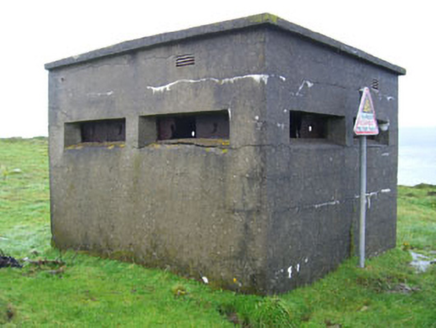 battery4.1 mi
Explorer Tom Battery in Ardaragh East on Bere Island is a pill box that’s been waiting for a French invasion that never quite…
 Greenane RockIslet · 4.1 mi
Explorer Tom Greenane Rock in County Cork definitely does something shady when nobody’s looking, like rearranging its own stones.…
 Bere IslandIsland · 4.6 mi
Explorer Tom Bere Island has the look of a harbour guard who never clocks off. Bere Island lies across Bantry Bay like a long stone…
 KnockanalligMountain / peak · 5.1 mi
Explorer Tom Knockanallig is probably posting photos of its own summit on social media with hashtags like #BereIslandKing. It’s very…
More archaeology and monuments in County Cork · All of County Cork

What do you know about this place?Tap to add a comment or ask a question