What is recorded here
From OpenStreetMap (© OpenStreetMap contributors) w816835497
Places near here
Photo credits
- Wanfried-Dublin, Wikimedia Commons · CC BY-SA 4.0
- Kenneth Allen, Wikimedia Commons · CC BY-SA 2.0
- National Inventory of Architectural Heritage
- Oliver Dixon, Wikimedia Commons · CC BY-SA 2.0
- Pampuco, Wikimedia Commons · CC BY-SA 4.0
- Kenneth Allen, Geograph · CC BY-SA 2.0
- Ronnie Nijboer, Wikimedia Commons · CC0
- David Dixon, Geograph · CC BY-SA 2.0
.jpg/250px-Carnaghan_(7).jpg "Photo: Wanfried-Dublin, Wikimedia Commons · CC BY-SA 4.0") Carnaghan Portal TombPortal tomb · 968 yd
Carnaghan Portal TombPortal tomb · 968 ydExplorer Tom Carnaghan Portal Tomb stands on Inch Island, watching over Lough Swilly with two tall stones framing its entrance. Locals call it the King’s Grave, and Fagan found crocks of bones nearby back in 1846. It’s a royal spot that still feels a bit mysterious and isolated.
 Inch Island Standing Stones and Megalithic TombPublicly named standing stone · 971 yd
Explorer Tom Inch Island Standing Stones and Megalithic Tomb sound like they got stuck on a tiny island just to avoid the crowd. I bet the stones are playing a very long game of statues while the sea nips at their toes.
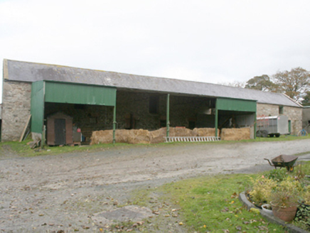 farmyard complex1039 yd
Explorer Tom Farmyard complex in Castlequarter has buildings from around 1890 standing around a yard. One has an open-fronted lean-to held up by cast-iron columns. I thought I was looking at a workaday shed; those columns give it surprisingly grand manners.
 Old CastleCastle, tower house · 1145 yd
Explorer Tom Old Castle is a stubborn tower house that has survived since 1454, even if Mr. Skinner never finished his rebuild. The east half stands three storeys high with intact vaults and murder holes, while the rest lies in ruins. It’s a proper cliff-edge survivor that refuses to fully crumble away.
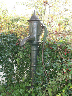 water pump1197 yd
Explorer Tom Water pump in Carnaghan has a cast-iron handle called a cow-tail. The survey says the pump is out of use, but that name has me looking for the rest of the imaginary cow. Is the domed cap its hat?
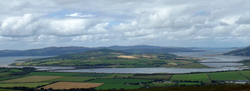 InchIsland · 1633 yd
Explorer Tom Inch Island in County Donegal is visible from Grianan of Aileach, a significant island dotting the dramatic landscape.
 Burt CastleCastle, tower house · 2.4 mi
Explorer Tom Burt Castle's roofless keep still stands on the hill, with two round corner towers and rows of gun-loops. The old account even records a spiral stair with broken steps in the south-west tower. I would admire that stubborn stonework from safe ground; those steps sound like trouble.
 The BeachcomberPub · 2.9 mi
Explorer Tom The Beachcomber in Rathmullan is probably full of people pretending to understand the tide charts. Grab a pint and listen to them argue about surfing; it's better than reality anyway and much cheaper therapy.
 The White HartePub · 3.0 mi
Explorer Tom The White Harte in Rathmullan is right by Kerrs Bay, likely watching boats go by. It's a pub with a name that sounds like a unicorn. Go ask for one, but don't be surprised when you get a pint instead.
 RathmullanOfficial bathing water · 3.0 mi
Explorer Tom Rathmullan Beach starts at the pier and keeps strolling past Kinnegar toward the Glebe outcrop. If sand could wear walking boots, this strip would be lacing them up. A 2019 Lough Swilly report also notes otters among the wildlife; I would leave any real otter sighting to patience and luck.
 Wych Elm3.0 mi
Explorer Tom Wych Elm stands tall in County Donegal; I imagine its roots gripping the earth like an old friend’s steady hand.
 LisfannonOfficial bathing water · 3.1 mi
Explorer Tom Lisfannon is the sort of beach that changes its stage set with the tide. The Swilly estuary lays out shallow water, sand and mud flats in turn. A 2019 state report notes otters among the wildlife here. I would watch the stage changes from dry ground and let the tide run the show.
More beaches and strands in County Donegal · All of County Donegal

What do you know about this place?Tap to add a comment or ask a question