What is recorded here
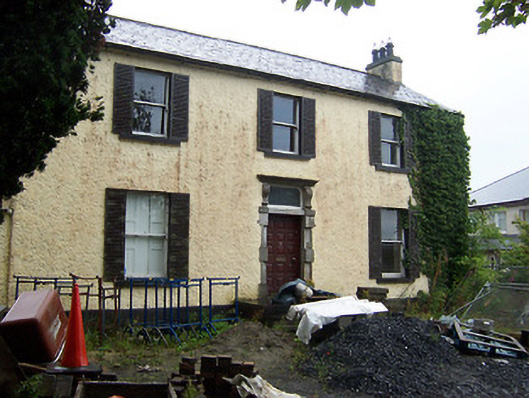
Detached three-bay two-storey over basement house, built c.1800, with two storey return to rear (southwest). Pitched natural slate roof with a projecting eaves course and with rendered chimneystacks to either gable end. Roughcast rendered walls over smooth rendered plinth. Square-headed openings with one-over-one pane timber sash windows and cut stone sills. Modern external shutters to front façade windows. Square-headed doorway to centre of main façade having a cut stone block-and-start surround with a fluted lintel and an early timber panelled door. Rectangular overlight, added c.1860, having a cut stone cornice supported on elongated console brackets. Set in own grounds with outbuildings to the south. Bounded on road frontage by rubble limestone wall. Located to the southeast of Mullingar adjacent to Saunder’s Bridge (15310086).
An attractive house of balanced proportions. It retains its early form, together with important early features and materials. The house is distinguished by the interesting cut stone doorcase, which is of artistic merit. This doorcase is probably the result of two distinct phases. The fluted lintel suggests a late eighteenth-century date, whilst the rectangular overlight may have been added during the mid nineteenth-century. This type of overlight seems to be relatively common in Mullingar. Other examples can be found at The Greville Arms (15310107) and The Bank of Ireland, Dominick Street (15310060). Millmount House appears to be marked as a 'School House' on an 1837 Ordnance Survey Map of Mullingar, albeit with a longer return to the rear. It is possible that this structure was originally built as a school or school masters' house and that it was significantly rebuilt c. 1860 when the doorcase was altered. The present building, along with the attendant grounds and boundary wall, creates an attractive and important feature in the streetscape around Saunder's Bridge (15310086) and makes a strong positive contribution to the architectural heritage of Mullingar.
This does not grant access. Most recorded buildings are privately owned; view them only from public ground unless the owner allows entry.
Places near here
 Saunder's Bridgebridge · 69 yd
 harbour/dock/portharbour/dock/port · 334 yd
 IndicatedEcclesiastical enclosure · 530 yd
 Petits Castle Mote & Mill (Site of)Castle, unclassified · 836 yd
 Priests WellHoly well · 885 yd
 Augustinian Monks Memorial StatueMemorial · 971 yd
 Site of CastleCastle, unclassified · 1014 yd
 The Chimera GalleryGallery · 1114 yd
 Famine MemorialMemorial · 1139 yd
 Mullingar Cathedral MuseumMuseum · 1406 yd
 Saint Brigid's WellSpring · 2.3 mi
 Lady's IslandWood · 3.3 mi
Other information
Photo: National Inventory of Architectural Heritage · Website use allowed for educational or private purposes with source credit