
What is recorded here
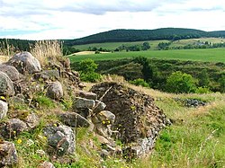
Mill of Kincraigie is a barrow in Aberdeenshire, Scotland.
From the Historic Environment Scotland record 76920
The historic-place record does not grant public access. Check current conditions and ownership before entering land or a building.
Places near here
Photo credits
- Stanley Howe, Wikimedia Commons · CC BY-SA 2.0
- Andrew Wood, Wikimedia Commons · CC BY-SA 2.0
- Anne Burgess, Wikimedia Commons · CC BY-SA 2.0
- Mick Garratt, Wikimedia Commons · CC BY-SA 2.0
- Bill Harrison, Wikimedia Commons · CC BY-SA 2.0
- Carron K, Wikimedia Commons · CC BY-SA 2.0
 Oldtown PlantationForest · 314 yd
 Mains of KincraigieHouse · 1032 yd
 SpringbankCottage (19th Century), Lade, Mill Pond, Threshing Mill (19th Century) · 1060 yd
 TillychardochStone Circle (bronze Age) (possible) · 1167 ydSpringbankField System · 1340 yd
 Muirton WoodForest · 1.0 mi
 Tomnaverie Stone CircleHeritage attraction · 1.1 mi
 Coull CastleCastle (medieval), Coin(s) · 1.2 mi
 MacRobert Memorial HallMemorial · 1.5 mi
.jpg/250px-Tarland_war_memorial_(geograph_5527591).jpg "Photo: Bill Harrison, Wikimedia Commons · CC BY-SA 2.0") Tarland War MemorialMemorial · 1.5 mi
Tarland War MemorialMemorial · 1.5 mi Queen's ViewViewpoint · 1.8 mi
 Scar HillMountain / peak · 2.1 mi
More archaeology and monuments in Aberdeenshire · All of Aberdeenshire
What do you know about this place?