
Places near here
Photo credits
- National Inventory of Architectural Heritage
- Michael Dibb, Geograph · CC BY-SA 2.0
- David Quinn, Geograph · CC BY-SA 2.0
- Eirian Evans, Geograph · CC BY-SA 2.0
- Aoifer, Wikimedia Commons · CC BY-SA 4.0
- Sarah777 at English Wikipedia, Wikimedia Commons · Public domain
- Klondikeger, Wikimedia Commons · CC BY-SA 4.0
Explorer Tom Rathdown Castle now shares its ancient moat with a decommissioned sewage plant, which is either genius recycling or a very smelly joke on history. One tower hung on until the 1800s before giving up entirely. Make up your own legend and I'll swear it's true.
 Slieve CillínHouse · 1193 yd
Explorer Tom Slieve Cillín is in a bitter rivalry with the local church because it thinks its roofline is superior. It’s a well-preserved 1850 house that adds character to the surroundings by being slightly pretentious about its own angles. If you blink, it might accuse you of staring at its windows. Look
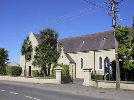 Saint Kilian's Catholic ChurchChurch/chapel · 1239 yd
Explorer Tom Saint Kilian's Catholic Church in Kindlestown Lower, County Wicklow, is being judged by the local rabbits who think it’s a really fancy burrow. It’s simple and rural, adding variety to the streetscape without making a fuss. A quiet spot for a chat!
 The CoveBeach / strand · 1416 yd
Explorer Tom The other Cove would totally ace a reality show because it’s got great lighting and a dramatic backdrop for every single scene. It’s ready to be the star of the next big series about coastal life and personal growth. A good place to forget your phone for ten minutes.
Bray Greystones Cliff WalkWalking route · 1721 ydExplorer Tom Bray Greystones Cliff Walk in County Wicklow is currently half-closed due to danger, which it finds hilarious because it’s been dodging tourists' bad footwear for years anyway. It posts about its exclusivity constantly on social media. Hum something sad nearby, it adds atmosphere.
Greystones WayWalking route · 1.1 miExplorer Tom Greystones Way has a curse that only affects people who don't wave at the houses. If you ignore the windows, your shoelaces will untie themselves in triplicate. Go on, count the windows and get it wrong like I did.
 Bray Greystones ViewViewpoint · 1.2 mi
Explorer Tom Bray Greystones View would tell its younger self to stop worrying about the cliffs and start eating more sandwiches. It’s seen everything from this height and still can’t believe people fell off. Bring biscuits, every good story needs biscuits.
 Greystones South BeachBeach / strand · 1.2 mi
Explorer Tom Greystones South Beach rates its visitors based on how loudly they complain about the cold water; it loves a good moan over a cuppa. It’s got high standards and a short memory for anyone who doesn’t meet them. Ten minutes here and you'll have a yarn for the pub.
 Kindlestown Castle (in ruins)Castle, hall-house · 1.3 mi
Explorer Tom Kindlestown Castle has a secret it only tells after three pints: it’s actually terrified of the vault because it thinks it’s listening back. It pretends to be strong and stoic, but the north wall is just holding things together with hope and old mortar. If it rains, blame me.
 Bray Head HillMountain / peak · 1.4 mi
Explorer Tom Bray Head Hill holds a fake world record for the fastest wind chime ever broken by a pigeon in flight. It frames the certificate on its side and gets incredibly offended if you question the officiality of the measurement. A good place to forget your phone for ten minutes.
 Little Sugar LoafMountain / peak · 1.8 mi
Explorer Tom Little Sugar Loaf is what Saint Patrick would have called 'a bit much' when he saw its pointy little head sticking up near Bray. It’s essentially a big stone tooth that never got pulled. Take the long way round, it deserves the effort.
 Glen of the DownsNature reserve · 2.4 mi
Explorer Tom Glen of the Downs looks like somebody cut a green passage through Wicklow and forgot to tell the trees to stop growing. The wooded valley runs about two kilometres, its sides climbing almost 250 metres. Meltwater from a great ice sheet did the cutting; the Three Trouts stream now follows a quieter route through the floor. A 59-hectare nature reserve protects part of it. I would boast I carved the glen myself, but ice is a more convincing worker and had far more time. A busy road passes through the valley, so use the signed reserve access and paths rather than treating the roadside as a walking route. Check current trail conditions and keep to safe ground in wet weather. Listen for water once the traffic fades. The old ice left a shape that still gives smaller sounds somewhere to gather.
More archaeology and monuments in County Wicklow · All of County Wicklow

What do you know about this place?Tap to add a comment or ask a question