What is recorded here
Mid Park is a farmstead in Dumfries and Galloway, Scotland.
From the Historic Environment Scotland record 94940
The historic-place record does not grant public access. Check current conditions and ownership before entering land or a building.
Places near here
Photo credits
- John Lawson, Wikimedia Commons · CC BY-SA 2.0
- Kevin Rae, Wikimedia Commons · CC BY-SA 2.0
- David Liddle, Wikimedia Commons · CC BY-SA 2.0
- Walter Baxter, Wikimedia Commons · CC BY-SA 2.0
- Andrew Smith, Wikimedia Commons · CC BY-SA 2.0
- Richard Webb, Wikimedia Commons · CC BY-SA 2.0
.jpg/250px-Westerhall,_Bentspath_(geograph_1877703).jpg "Photo: John Lawson, Wikimedia Commons · CC BY-SA 2.0") WesterhallHouse (18th Century), Tower House (medieval) · 639 yd
WesterhallHouse (18th Century), Tower House (medieval) · 639 yd Bentpath, Westerkirk Parish Church, Johnstone MausoleumMausoleum · 766 yd
 Bentpath, Esk BridgeRoad Bridge · 800 yd
 Bentpath, Westerkirk Parish ChurchBurial Ground (medieval) - (19th Century), Church (19th Century) (1881), Church (medieval), Gate Pier(s) (19th Century), Wall (post Medieval), War Memorial(s) (20th Century) · 822 yd
 Telford MemorialMemorial · 1014 yd
 Bentpath, Westerkirk Parish LibraryLibrary · 1022 yd
 Upper Brydonswell KnoweMountain / peak · 1111 yd
 Bombie HillMountain / peak · 1.2 mi
 Burnfoot PlantationWood · 1.7 mi
 The Lady Florance StoneMemorial · 2.7 mi
 Gallowside WoodWood · 3.5 mi
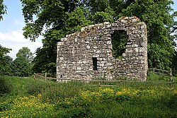 Langholm CastleTower House (16th Century) · 4.1 mi
More historic places in Dumfries and Galloway · All of Dumfries and Galloway
What do you know about this place?