What is recorded here
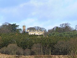
Megginch is an axehead in Perth and Kinross, Scotland.
From the Historic Environment Scotland record 30518
The historic-place record does not grant public access. Check current conditions and ownership before entering land or a building.
Places near here
Photo credits
- JThomas, Wikimedia Commons · CC BY-SA 2.0
- Richard Webb, Wikimedia Commons · CC BY-SA 2.0
- James Allan, Wikimedia Commons · CC BY-SA 2.0
- Glyn Baker, Wikimedia Commons · CC BY-SA 2.0
- Scott Cormie, Wikimedia Commons · CC BY-SA 2.0
- James Denham, Wikimedia Commons · CC BY-SA 2.0
- Gordon Hatton, Wikimedia Commons · CC BY-SA 2.0
- Stanley Howe, Wikimedia Commons · CC BY-SA 2.0
- Bob Moncrieff, Wikimedia Commons · CC BY-SA 2.0
 InchcoonansRing Ditch (prehistoric) · 478 yd
 InchcoonansBuilding(s), Unenclosed Settlement (prehistoric) · 724 yd
 Pannoch WoodWood · 904 yd
 Errol, Railway Station and Signal BoxRailway Station (19th Century), Signal Box (19th Century) · 1601 yd
 Errol Park, Walled GardenWalled Garden · 1642 yd
 Cairn O'Mohr WineryHeritage attraction · 1.0 mi
 Lornie WoodForest · 1.5 mi
 KilspindieArchitectural Fragment(s) (17th Century), Castle (medieval) · 1.7 mi
 Pitroddie FarmArchitectural Fragment(s) (17th Century) - (18th Century), Tower House (medieval) (possible) · 1.7 mi
 Lindores Abbey (ruins)Heritage attraction · 3.4 mi
 Victory FountainMemorial · 3.6 mi
 Newburgh CemeteryCemetery (19th Century) · 3.7 mi
More archaeology and monuments in Perth and Kinross · All of Perth and Kinross
What do you know about this place?