
What is recorded here
Kinahan (1889) noted 'two rude ancient structures of squarish slabs of stone set on edge' on the SE slope of Crockmore in the above townland. Then known to locals as 'Dane's houses...they are so very rude that one would easily pass them by as dilapidated shelters for lambs or calves'. Kinahan saw weathered traces of…
Read the whole record
From the National Monuments Service (Archaeological Survey of Ireland) record DG036-033
Places near here
Photo credits
- Maker not stated on source page, archaeology.org
- National Inventory of Architectural Heritage
- Maker not stated on source page, uk.pinterest.com
- Maker not stated on source page, www.ireland.com
- Kenneth Allen, Geograph · CC BY-SA 2.0
- Maker not stated on source page, en.wikipedia.org
- Maker not stated on source page, www.dreamstime.com
- sarah gallagher, Geograph · CC BY-SA 2.0
- Proinsias Carr / Donegal GAA, donegalgaa.ie
- Maker not stated on source page, www.pinterest.com
- Richard Webb, Geograph · CC BY-SA 2.0
 Megalithic tomb in AghanursanMegalithic tomb · 1.2 mi
Explorer Tom Megalithic tomb in Aghanursan was once spotted on the western side of Columbkille Lough, but now it’s vanished into the…
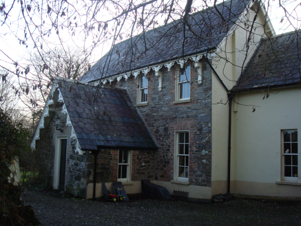 The VicarageRectory/glebe/vicarage/curate's house · 1.3 mi
Explorer Tom The Vicarage in Glenalla has a scalloped and squared banded slate roof that looks like a giant, very crunchy biscuit. I…
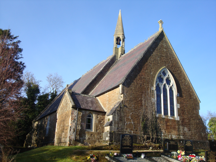 Saint Columbkille's Church (Aughnish)Church/chapel · 1.4 mi
Explorer Tom An older survey described Saint Columbkille's Church (Aughnish) with a bellcote perched where the nave meets the…
 Standing stone in Dunmore (carrowkeel Ed)Standing stone · 1.6 mi
Explorer Tom Standing stone in Dunmore is having a really bad day with its paperwork. Its coordinates match exactly where a pit…
 Hewitson's IslandIslet · 1.7 mi
Explorer Tom Hewitson's Island in County Donegal would say in a job interview that it has great stability and zero maintenance…
 The Traveller's InnRestaurant · 1.8 mi
Explorer Tom The Traveller's Inn at Kilmacrennan Road junction might be hiding a map in the sauce. I bet the chef knows where the…
 Mapped cemeteryCemetery · 1.9 mi
Explorer Tom Mapped cemetery handles nosy neighbours by pretending not to hear them, which is an ancient skill that takes decades of…
 Mapped graveyardGraveyard · 1.9 mi
Explorer Tom This unnamed graveyard in County Donegal had a massive falling out with the next village over who stole their windmill…
 Rough IslandIslet · 2.0 mi
Explorer Tom Rough Island in Mulroy Bay has made its New Year’s resolution: to be less rude and more reliable. It promises to stay…
 Moyle View Park, Milford GAAGAA ground · 2.1 mi
 Woodquarter - Forest trailOfficial walking route · 2.4 mi
Explorer Tom Woodquarter Forest trail is just 1.1 km but feels like a whole adventure because a fox once took charge of the path and…
 WoodquarterForest recreation place · 2.4 mi
Explorer Tom Woodquarter begins on the western edge of Mulroy Bay and promptly makes a nonsense of the idea that a forest walk is…
More archaeology and monuments in County Donegal · All of County Donegal

What do you know about this place?Tap to add a comment or ask a question