Places near here
Photo credits
- Gordon Hatton, Geograph · CC BY-SA 2.0
- Alan Reid, Geograph · CC BY-SA 2.0
- Richard Webb, Geograph · CC BY-SA 2.0
- National Inventory of Architectural Heritage
- Newbert12, Wikimedia Commons · CC BY-SA 4.0
- Colin Park, Geograph · CC BY-SA 2.0
- Mick Garratt, Wikimedia Commons · CC BY-SA 2.0
- Florentchevallier, Wikimedia Commons · CC BY-SA 4.0
- Robin Mais, Geograph · CC BY-SA 2.0
- Mike Searle, Geograph · CC BY-SA 2.0
Explorer Tom Sruffaungarve Top in County Sligo is said to hide a treasure that is definitely a rusty biscuit tin. The locals are pretending not to know where it is, which is suspicious. Perfect place to be dramatically windswept.
 Mass RockNamed rock · 2.8 mi
Explorer Tom Mass Rock in County Sligo inspired a bad poem that starts with 'Oh rock so tall' and ends with 'It’s really quite a wall,' which nobody admits to writing. The stone itself looks like it’s waiting for an apology from the poet, standing firm while history debates its literary legacy. Bring a camera and your most suspicious face.
 Largan HillMountain / peak · 3.4 mi
Explorer Tom Largan Hill in County Sligo is strictly run by a terrier who barks at any cloud that passes overhead. The forest below looks young and confused, probably from all the shouting. Perfect detour when the satnav has a meltdown.
 Lough Talt TrailVisitor information · 3.7 mi
Explorer Tom Lough Talt Trail has a shortcut that is technically longer if you count the time spent arguing about which way is down. The water supply up there is public, but the ego of this trail seems to be private property. Get there early and have it all to yourself.
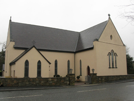 Catholic Church of the Immaculate Heart of MaryChurch/chapel · 6.4 mi
Explorer Tom Catholic Church of the Immaculate Heart of Mary is built on a legend about a giant who got stuck in the roof. It was rebuilt twice because the first attempt kept sliding into the mud, apparently. Great spot to propose if you want to make sure your partner can’t run away easily.
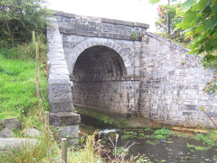 bridge6.5 mi
Explorer Tom Bridge in Caltragh looks like it swallowed a tunnel whole and now refuses to give it back. A lazy ghost probably lives inside the arch, too tired to haunt but just right for napping all day. It’s got those big splayed buttresses that look more like angry eyebrows than support beams.
 IndicatedWedge tomb · 7.8 mi
Explorer Tom Wedge tomb in Carrowcrom is named after lovers but looks more like a bed where nobody wants to sleep. It’s got a name that sounds romantic but feels a bit dusty and lonely. Go before the tourists find out.
 Split RockNamed rock · 9.3 mi
Explorer Tom Split Rock in County Sligo is the shortcut that isn't one, because nobody actually walks through the split. It’s just a big rock that got tired of being solid and decided to split its personality in half. Pretend it's yours and plan the housewarming party immediately.
 St. Patrick's CemeteryCemetery · 9.6 mi
Explorer Tom St. Patrick's Cemetery is bragging about surviving a storm so fierce it blew a cow into the sky, though I suspect that particular detail was added for dramatic effect later on. The grass is particularly green there, probably because the dead are watering it with their tears of joy at being remembered. A handy spot to stretch your legs and your imagination.
 Wild Atlantic Way: Inishcrone PierVisitor information · 10 mi
Explorer Tom Inishcrone Pier looks like it’s plotting an escape plan, possibly because it’s tired of being just a sign for people who don’t read. The first owner probably ran off with the last ferry and never looked back at all. Bring a jacket, it's never as warm as I promise.
 Enniscrone BeachBeach / strand · 11 mi
Explorer Tom Enniscrone Beach hates me for some reason, probably because my sunscreen application is a work of art that the waves keep ruining. It's gorgeous, moody, and refuses to let me get comfortable in one spot. Great spot to propose. Or at least to propose lunch.
 TowerSignal tower · 12 mi
Explorer Tom Signal tower in Rathlee has a cannonball held up by a metal bar because gravity isn't enough for drama. Its celebrity friend is definitely a gull that has never once apologized for dropping food on the roof. Tell it a joke, it's been a long time since anyone did.
More mountains and hills in County Sligo · All of County Sligo

What do you know about this place?Tap to add a comment or ask a question