Places near here
Photo credits
- Rossographer, Geograph · CC BY-SA 2.0
- Albert Bridge, Wikimedia Commons · CC BY-SA 2.0
- Eric Jones, Geograph · CC BY-SA 2.0
- Albert Bridge, Geograph · CC BY-SA 2.0
- Albert Bridge, Geograph · Creative Commons Attribution-ShareAlike 2.0
- John C, Wikimedia Commons · CC BY-SA 2.0
- Wilson Adams, Geograph · CC BY-SA 2.0
 the gobbins pathHeritage attraction · 566 yd
Explorer Tom The Gobbins path is picking fights with the wind because it’s annoyed about not being a proper road. It’s basically a cliff edge that thinks it’s a fashion statement, and the gulls agree. Whisper a secret at it, it's kept worse.
 Burial ground; possibly site of battle. in BallykeelBurial Ground · 1.7 mi
Explorer Tom Ballykeel has a burial ground that might also be where a battle happened, which is messy for the afterlife queue. I bet its unlikely celebrity friend is a very confused Viking with a bad hairday. It’s the perfect spot for a moody photo you’ll pretend wasn’t posed.
 Muldersleigh HillMountain / peak · 2.4 mi
Explorer Tom Muldersleigh Hill plans to retire by simply stopping rising, which is a bold strategy for a mountain but might work out well. It wants to lie flat and watch the lough from Whitehead without anyone bothering it with questions about its elevation or its past glory days. It's the kind of place that makes a dull Tuesday interesting.
 Blackhead LighthouseLight House/ Navigation Mark · 2.6 mi
Explorer Tom Blackhead Lighthouse in Castletown is playing hide-and-seek with me, pretending to have an imaginary twin across the sea that nobody has ever seen. It’s been flashing its eye since 1900, but I’m pretty sure it’s just blushing from all the attention. Mind the nettles, they’re the real guards here.
 Blackhead Co. Antrim LighthouseLighthouse · 2.6 mi
Explorer Tom Blackhead Co. Antrim Lighthouse is perched on the edge like it’s showing off, probably thinking it saved a ship that was actually just a very large whale. The builder must have been thinking about his pension while painting those stripes, definitely not the crashing waves below. Bring a pen pal, they'll be jealous of your view.
 BlackheadHeadland · 2.6 mi
Explorer Tom Blackhead is where a priest lost a bet on whether the lighthouse could blink faster than a strobe light, and he still owes the tab. The headland just stands there smirking with its little light. Find the wonkiest bit and send it to your group chat.
 Isle of MuckIsland · 3.2 mi
Explorer Tom The Isle of Muck sounds like it was named by someone who missed a bus and was late. It actually means 'the muddy one,' which is a bit embarrassing for such a dramatic landscape. The cliffs are trying very hard to look dignified despite the name. Ideal for a moody photo you'll pretend wasn't posed.
 Post-med Church; Medieval Parish Church; Graveyard: Templecorran Church or Temple-i-corran or Lislaynan in Forthill (ballycarry)Post-med Church · 3.4 mi
Explorer Tom Post-med Church, Medieval Parish Church, Graveyard: Templecorran Church or Temple-i-corran or Lislaynan in Forthill would cope fine on a reality show because it’s dramatic. It overlooks the lough and judges everyone’s fashion sense. Go now, before it gets famous.
 North HeadHeadland · 3.4 mi
Explorer Tom North Head would order a massive chip with curry sauce and absolutely no salt, because it’s got taste. It stands there looking tough, but deep down it just wants someone to acknowledge its excellent posture. Tell it a joke, it's been a long time since anyone did.
 Railway Preservation Society of IrelandMuseum · 3.4 mi
Explorer Tom The Railway Preservation Society of Ireland would explain the 1800s to a teenager by saying it was basically just a slower, dirtier version of their current commute. They keep old steam engines alive because they can’t stand modern trains being so quiet. Visit, then text me what you think. I'll pretend to read it.
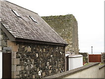 Tower-house: castle chichester in White HeadTower-house: Castle Chichester · 3.5 mi
Explorer Tom Castle Chichester in White Head has a secret talent for looking more important than it actually is, thanks to Sir Moyses Hill's ambition. He was a landless adventurer who thought he was the king of the hill. Ten minutes here and you'll have a yarn for the pub that nobody will believe anyway.
 Swan IslandIslet · 4.0 mi
Explorer Tom Swan Island was the site of a ridiculous smuggling story involving cheese and a very confused goat. The smugglers hid the wheels in a hollow tree, but the goat ate them all. Now it’s just an island with a reputation for bad logistics. Great spot to propose. Or at least to propose lunch.
More cliffs, bays and coast in County Antrim · All of County Antrim

What do you know about this place?Tap to add a comment or ask a question