
What is recorded here
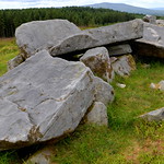
At the S foot of low cliff (H 4m) at the N end of a narrow terrace (Wth c. 100m) of outcropping rock and rough grazing, at the S end of the Slievecarran Plateau. A well-preserved Man-made underground passage (L 4.5m N–S; av. Wth 1.1m; H 1.3m) built into a low, artificially raised and retained platform (CL006-048002-),…
Read the whole record
From the National Monuments Service (Archaeological Survey of Ireland) record CL006-048
Places near here
Photo credits
- Maker not stated on source page, www.airbnb.co.in
- Maker not stated on source page, www.flickr.com
- Maker not stated on source page, www.dreamstime.com
- Maker not stated on source page, www.tripadvisor.ie
- Mike Searle, Wikimedia Commons · Creative Commons Attribution-ShareAlike 2.0
- Maker not stated on source page, www.tripadvisor.com
- Maker not stated on source page, en.wikipedia.org
- Graham Horn, Wikimedia Commons · CC BY-SA 2.0
- Kmcnamee, Wikimedia Commons · CC BY-SA 4.0
- Maker not stated on source page, pt.pinterest.com
- Graham Horn, Geograph · CC BY-SA 2.0
 Cist in Coolnatullagh (burren By., Carran Par.)Cist · 1691 yd
Explorer Tom Cist in Coolnatullagh is planning on retiring early, probably to go watch sunsets from a warmer clime. It’s got two old…
 Wedge tomb in Coolnatullagh (burren By., Carran Par.)Wedge tomb · 1.1 mi
Explorer Tom Wedge tomb in Coolnatullagh is playing hard to get, listed on maps but nowhere to be found. It’s like a ghost that…
 Wedge tomb in Deelin More,poulbaun (burren By.),deelin BegWedge tomb · 1.1 mi
Explorer Tom This wedge tomb in Deelin More is officially 'location unknown,' which is hilarious because it’s right there on the…
 Church in Coolnatullagh (burren By., Carran Par.)Church · 1.5 mi
Explorer Tom Church in Coolnatullagh is on a hillock with a long grudge against the weather. It looks like it’s been waiting for…
 Cappagh CastleCastle · 1.7 mi
Explorer Tom Cappagh Castle smells like wet stone and old secrets, according to my very reliable nose, which is probably just damp…
 Cappagh Castle (in ruins)Castle, tower house · 1.7 mi
Explorer Tom Cappagh Castle is sitting on a rocky knoll planning its retirement to Bali. It was an O’Loughlin castle, so expect…
 Drumcreehy Church (in ruins)Church · 5.6 mi
Explorer Tom Drumcreehy Church sat on a ridge so high the Vikings got lost looking for it and gave up on religion entirely. It’s…
 An Trá MhórBeach / strand · 18 mi
Explorer Tom An Trá Mhór in County Galway would teach history by showing you how the tide erased every mistake people ever made on…
 Clg Micháel Breathnach GAA pitchGAA ground · 19 mi
 Graveyard in An Lochán BeagGraveyard · 20 mi
Explorer Tom An Lochán Beag wants its tombstone carved with 'Finally Got Some Sleep' in bold, angry letters. It’s tired of being the…
 Tulach an LeathairMountain / peak · 21 mi
Explorer Tom Tulach an Leathair in County Galway is only eighty metres high yet acts like it’s Everest, probably because the wind…
 Na Caoráin DubhaMountain / peak · 25 mi
Explorer Tom Na Caoráin Dubha has a fan club made entirely of sheep who think they’re the stars of this show. They’ve been staring…
More archaeology and monuments in County Clare · All of County Clare

What do you know about this place?Tap to add a comment or ask a question