
What is recorded here
Mains of Mulben is a house in Moray, Scotland.
From the Historic Environment Scotland record 75791
The historic-place record does not grant public access. Check current conditions and ownership before entering land or a building.
Places near here
Photo credits
- Anne Burgess, Wikimedia Commons · CC BY-SA 2.0
- Lucas Kendall, Wikimedia Commons · CC BY-SA 2.0
- thejackrustles, Wikimedia Commons · CC BY-SA 2.0
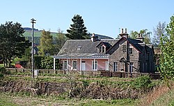 Mulben StationRailway Station (19th Century) · 549 yd
 Mulben War MemorialMemorial · 833 yd
 Upper MulbenFarmstead · 1214 yd
 ScotshillCottage, Enclosure · 1669 yd
 BalnabreichCastle (medieval) · 1695 ydScotshillCottage, Enclosure · 1.0 mi
 Stripeside WoodWood · 1.0 mi
 Hill of MulderieMountain / peak · 1.8 mi
 Thief's HillMountain / peak · 2.0 mi
 Hill of TowieNo Class (event) · 2.8 mi
 Darnet WoodForest · 3.2 mi
 The Earth PillarsNamed rock · 3.4 mi
More historic places in Moray · All of Moray
What do you know about this place?