
What is recorded here
Luing, Cuan is a rig and furrow in Argyll and Bute, Scotland.
Places near here
Photo credits
- Craig Brown, Wikimedia Commons · CC BY-SA 2.0
- Jonathan Thacker, Wikimedia Commons · CC BY-SA 2.0
- M J Richardson, Wikimedia Commons · CC BY-SA 2.0
- Anne Burgess, Wikimedia Commons · CC BY-SA 2.0
- David Brown, Wikimedia Commons · CC BY-SA 2.0
- Walter Baxter, Wikimedia Commons · CC BY-SA 2.0
- Gordon Brown, Wikimedia Commons · CC BY-SA 2.0
- User:Klaus with K, Wikimedia Commons · CC BY-SA 3.0
- James T M Towill, Wikimedia Commons · CC BY-SA 2.0
- Craig Wallace, Wikimedia Commons · CC BY-SA 2.0
 Isle of LuingFindspot (21st Century), Arrowhead (late Neolithic) - (bronze Age), Flake (late Neolithic) - (bronze Age) · 81 yd
 Luing, South CuanQuarry Scoop (post Medieval) · 311 yd
 LuingEnclosure (post Medieval) · 402 yd
 Seil, North Cuan, Old KirkChurch (18th Century) (1735), Infectious Diseases Hospital (20th Century) (1901)-(1932) · 641 yd
 Atlantic Islands CentreMuseum · 1680 yd
 Luing Millennium CairnMemorial · 1.2 mi
 Seil, Balvicar, CemeteryCemetery (20th Century) · 1.8 mi
 Scoul EileanIslet · 2.0 mi
 Easdale Folk MuseumMuseum · 2.0 mi
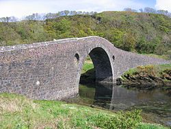 SeilIsland · 2.3 mi
 Dùn MòrMountain / peak · 2.4 mi
 Meall a' ChàiseMountain / peak · 2.5 mi
More archaeology and monuments in Argyll and Bute · All of Argyll and Bute

What do you know about this place?Tap to add a comment or ask a question