
What is recorded here
Lochan Na H-airigh is a building in Argyll and Bute, Scotland.
From the Historic Environment Scotland record 152036
The historic-place record does not grant public access. Check current conditions and ownership before entering land or a building.
Places near here
Photo credits
- Steven Brown, Wikimedia Commons · CC BY-SA 2.0
- Alan Reid, Wikimedia Commons · CC BY-SA 2.0
- Patrick Mackie, Wikimedia Commons · CC BY-SA 2.0
- Rude Health, Wikimedia Commons · CC BY-SA 2.0
- Trevor Littlewood, Wikimedia Commons · CC BY-SA 2.0
- sylvia duckworth, Wikimedia Commons · CC BY-SA 2.0
- PAUL FARMER, Wikimedia Commons · CC BY-SA 2.0
- User:Klaus with K, Wikimedia Commons · CC BY-SA 3.0
- Andrew Wood, Wikimedia Commons · CC BY-SA 2.0
- Jonathan Thacker, Wikimedia Commons · CC BY-SA 2.0
 Scammadale Road EndClearance Cairn · 1603 yd
 Glen GallainClearance Cairn · 1607 yd
 Glen RisdaleShieling Hut(s) (post Medieval) · 1.2 mi
 BarochrealTownship · 1.3 mi
 Battle of LagganmoreBattle · 1.4 mi
 Cruach nam FeàrnaMountain / peak · 2.2 mi
 An CreachanMountain / peak · 2.6 mi
 Ardmaddy CastleCountry House (18th Century), Tower House (medieval) · 3.0 mi
 Loch FeochanBay · 3.1 mi
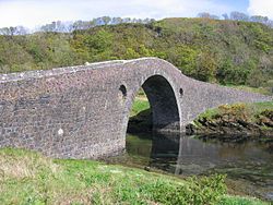 SeilIsland · 4.2 mi
 Kames BayBay · 4.3 mi
 Seil, Balvicar, CemeteryCemetery (20th Century) · 4.3 mi
More historic places in Argyll and Bute · All of Argyll and Bute
What do you know about this place?