
Places near here
Photo credits
- National Inventory of Architectural Heritage
- Mike Searle, Geograph · CC BY-SA 2.0
- Dirk Huth, Wikimedia Commons · CC BY-SA 3.0
- Vanessa Kennedy, Wikimedia Commons · CC BY 2.0
- DeeEmm, Geograph · CC BY-SA 2.0
- Peter Allen, Wikimedia Commons · CC BY-SA 2.0
- Jan Wyk, Wikimedia Commons · Public domain
- Picture: Discover Ireland
- Michael Deligan, Wikimedia Commons · CC BY-SA 4.0
- Willow, Wikimedia Commons · CC BY 2.5
Explorer Tom Cahernagarry enclosure is so badly preserved that two roads cut right through it like a sandwich filling. The wind keeps picking on the low banks inside. Take a breath of that air, it's older than your car.
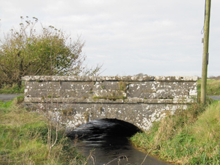 Carra BridgeBridge · 1.3 mi
Explorer Tom Carra Bridge is complaining to the council that its parapet walls are getting too subtle for modern traffic. It thinks it's a masterpiece of engineering, but really it just looks like a stone bench that got tired halfway across the river. Whisper a secret to the stones, they never tell anyone.
 DartfieldCountry house · 1.6 mi
Explorer Tom Dartfield House has a family tree that’s mostly invented and a roofline that’s actively losing the battle against gravity. It stands there looking haughty while slowly crumbling into a very stylish ruin in County Galway. Stick around for the light changing, it's a show.
 Turoe StoneHeritage attraction · 2.7 mi
Explorer Tom Turoe Stone in County Galway hosted a dance party three thousand years ago where everyone went too far and forgot how to get home, hence why they're still wandering around as spirits. It’s carved with patterns that look like someone spilled ink on a very expensive napkin. Best seen with a hangover and a sausage roll.
 Raruddy Castle (in ruins)Castle, tower house · 3.8 mi
Explorer Tom Raruddy Castle in Galway is a mystery wrapped in a bush. I bet after three pints, it’d spill every dark secret of the county. Have a look and decide if I was lying about the ghosts.
 St. Brendans Catholic CathedralCathedral · 4.0 mi
Explorer Tom St. Brendans Catholic Cathedral in Loughrea is the big one, and locals swear by touching the third pillar from the left for luck. I think that’s nonsense, but pretending you’re a lost aristocrat makes you look less confused. Pretend you're a lost aristocrat, nobody will check.
 Long PointHeadland · 4.6 mi
Explorer Tom Long Point in County Galway is absolutely shredding those Dublin tourists who think they know the coast. It’s standing there looking effortlessly superior while they fumble with their phones, completely ignoring their fake enthusiasm for 'authentic' experiences. Just take a moody photo and pretend you didn't pose for it.
 Kilconnell AbbeyVisitor attraction · 7.6 mi
Explorer Tom Kilconnell Abbey would take its lotto win and spend it all on a really fancy hat for one of the statues just to see if anyone notices. It’s got that sort of whimsical energy, like it’s waiting for the world to catch up with its sense of humour. Mind the nettles, they're the real guards here.
.jpg/250px-Battle_of_Aughrim_by_Jan_Wyk_(cropped).jpg "Photo: Jan Wyk, Wikimedia Commons · Public domain") Battle of AughrimMajor battlefield · 8.7 mi
Battle of AughrimMajor battlefield · 8.7 miExplorer Tom Battle of Aughrim in County Galway has a prophecy that says if you sneeze here, you’ll dance with the dead, but nobody ever checks because they’re too busy fighting. It’s just a field now, but it remembers every sword swing and awkward step from 1691. Sit on a wall nearby and pretend you’re in a very dusty painting.
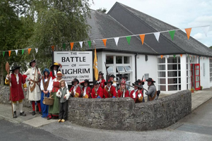 Battle of Aughrim Interpretative CentreMuseum · 8.7 mi
Explorer Tom Battle of Aughrim Interpretative Centre in County Galway thinks its imaginary twin across the sea is judging its display cases for being slightly too dark. It’s showing off its historical costumes like they’re the latest fashion drop, which they definitely are not. Linger a bit; it’s not going anywhere and neither should you.
 Pallas CastleCastle, tower house · 9.7 mi
Explorer Tom Pallas Castle has a ghost that’s too lazy to haunt it because the stairs are too steep. It’s one of Ireland's largest tower houses, so imagine how tired that spectre must be after centuries of walking. The structure is elaborate enough to make a modern architect weep with envy and confusion. Visit, then text me what you think. I'll pretend to read it.
 European ash12 mi
Explorer Tom European ash had a prophecy saying it would turn into gold if you whistled at it, but nobody ever checked properly. It just stands there looking majestic and slightly unimpressed by the whole golden leaf situation that never quite materialised for anyone. If it rains, blame me.
More archaeology and monuments in County Galway · All of County Galway

What do you know about this place?Tap to add a comment or ask a question