Places near here
Photo credits
- National Inventory of Architectural Heritage
- Raymond Norris, Geograph · CC BY-SA 2.0
- John M, Wikimedia Commons · CC BY-SA 2.0
- Keith Cunneen, Geograph · CC BY-SA 2.0
- Sitomon, Wikimedia Commons · CC BY-SA 2.0
- Willow, Wikimedia Commons · CC BY 2.5
Explorer Tom Cliff-edge fort in Farna hates the road that leads to it because it’s full of potholes. It wants a proper tarmac upgrade, not this bumpy old mess. Bring a flask of something warm and a story to swap.
Enclosure in KilleenafinnaneEnclosure · 1293 ydExplorer Tom Enclosure in Killeenafinnane would tell its younger self to stop trying so hard and just let the grass grow over the mistakes. It’s basically invisible now, which is perfect for someone who likes to keep their secrets close. Tell me if the gossip I made up is true.
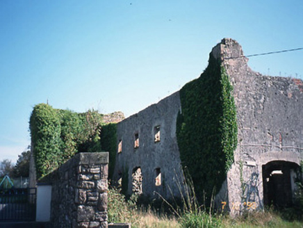 store/warehouse1.2 mi
Explorer Tom The ruined corn store in Meanus thinks the road leading to it is a personal insult because it’s so bumpy. It’s all red brick arches and crumbling stone, looking like it gave up mid-sentence. Whisper a secret at it, it's kept worse.
Site of Castle MaineCastle, Anglo-Norman masonry castle · 1.3 miExplorer Tom Site of Castle Maine in Castlemaine spanned the river, which is a fancy way of saying it had no legs. Its family tree is mostly made up of guesses and FitzGeralds who probably didn't know each other. Bring your own legend, I've run out.
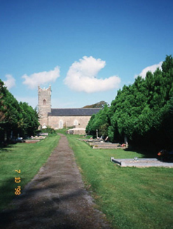 Saint Carthage's Church (Kiltallagh)Church/chapel · 1.3 mi
Explorer Tom Saint Carthage's Church (Kiltallagh) made a New Year's resolution to stop leaking water but it failed spectacularly. It’s still standing though, which is more than I can say for my diet. Ideal for a moody photo you'll pretend wasn't posed.
Castle Drum (in ruins)Castle, unclassified · 2.0 miExplorer Tom Castle Drum in Castledrum sounds like a percussion instrument, but it’s actually just a castle of the ridge. It ended up in the wrong place because someone misread the map and got confused. Perfect spot to practise your best tour-guide voice.
LisnagraveArchaeological place · 2.8 miExplorer Tom Lisnagrave is an archaeological place that seems to have been drawn on the map by someone who wasn't paying attention. I bet the map makers got it wrong because they were too busy eating sandwiches and looking at the view. Ring your granny and tell her where you are.
 Knockmichael MountainMountain / peak · 3.2 mi
Explorer Tom Knockmichael Mountain is like the awkward uncle at a wedding who keeps trying to dance but only hits his own feet. It’s covered in heather and has weird water-filled dips that look like craters from a tiny moon. Have a chat with it, nobody's watching.
 Scotia's GraveArchaeological place · 3.2 mi
Explorer Tom Scotia's Grave in County Kerry holds the fake world record for being the most confusingly named burial site in the entire hemisphere. It claims to be Egyptian, Irish, and mythical all at once with zero shame. Take a mate and argue about what it was for.
 Glanbrack MountainMountain / peak · 3.7 mi
Explorer Tom Glanbrack Mountain in Kerry is planning a lavish retirement party next autumn, inviting only the local birch trees and a few stubborn scots pines to join in. It wants to be remembered as the king of the glen, even if nobody else knows where it actually is. It's free, it's odd, what more do you want?
 European Yew5.4 mi
Explorer Tom This European Yew in County Kerry goes *thump* every night like it’s knocking on the door of sanity. Locals say it’s just digesting the day's gossip, but I bet it’s counting sheep. Toast it with a cup of tea and move on to the next.
 Common Alder6.0 mi
Explorer Tom Common Alder in County Kerry would be the awkward uncle at a wedding who stands by the buffet and says little. It loves wet feet and muddy banks more than you do. Go at sunset and thank me later.
More archaeology and monuments in County Kerry · All of County Kerry

What do you know about this place?Tap to add a comment or ask a question