Places near here
Photo credits
- David Dixon, Wikimedia Commons
- Seandálaí, Wikimedia Commons · CC BY-SA 4.0
- Mucklagh, Wikimedia Commons · CC BY-SA 4.0
- Humphrey Bolton, Wikimedia Commons · CC BY-SA 2.0
- Pam Brophy, Wikimedia Commons · CC BY-SA 2.0
- Gareth James, Wikimedia Commons · CC BY-SA 2.0
- National Inventory of Architectural Heritage
- Nigel Cox, Wikimedia Commons · CC BY-SA 2.0
- Bjørn Christian Tørrissen, Wikimedia Commons · CC BY-SA 3.0
- Pampuco, Wikimedia Commons · CC BY-SA 4.0
- Warrenfish, Wikimedia Commons · CC BY-SA 3.0
- David Dixon, Geograph · CC BY-SA 2.0
 Fionntrá (Ventry) BeachBeach · 1.2 mi
Explorer Tom Fionntrá curls around Ventry Harbour as if the Dingle Peninsula saved a sandy smile for itself. Fáilte Ireland calls it…
 Grave YardGraveyard · 1.2 mi
Explorer Tom Graveyard in Fionntrá has been the subject of priestly disputes since the fourteenth century, which is just fancy talk…
 Séipéal Chaitlín Naofa [Saint Catherine's Catholic Church]Church/chapel · 1.6 mi
Explorer Tom Séipéal Chaitlín Naofa would cope brilliantly on a reality show because it is the only one who speaks Irish properly.…
 DunbegPromontory fort, coastal · 2.2 mi
Explorer Tom Dunbeg in Fán thinks Dublin tourists are just noisy ghosts who don't know how to walk. The sea is slowly eating its…
 Dunbeg FortHeritage attraction · 2.2 mi
Explorer Tom Dunbeg Fort chose a dramatic Kerry cliff, and the sea has been collecting pieces of it ever since. Its wall once closed…
 Irish Famine CottagesMuseum · 2.3 mi
Explorer Tom The Irish Famine Cottages on Slea Head Drive stand amid West Kerry's glorious scenery. Step into the old Kavanagh…
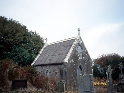 Reilig Ráithín Uí Bhuaigh [Reheenyhooig Graveyard]Mausoleum · 2.4 mi
Explorer Tom Reilig Ráithín Uí Bhuaigh’s least favourite visitor is definitely the postman who keeps ringing the doorbell. It’s a…
 Rahinnane Castle (in ruins)Castle, tower house · 2.6 mi
Explorer Tom Rahinnane Castle would ace a job interview by listing its surviving turret as a key asset. The eastern sector is just…
 Sliabh an IolairMountain / peak · 3.2 mi
Explorer Tom Sliabh an Iolair means eagle mountain, though the best known arrival here came on wings made of metal. Charles…
 Cnoc na CeathrúnMountain / peak · 3.3 mi
Explorer Tom Cnoc na Ceathrún stands south of Dingle with Eask Tower on its crown, a stone finger pointing seaward as if the hill…
 Eask TowerViewpoint · 3.3 mi
Explorer Tom Eask Tower stands over Dingle Harbour like a stone finger trying to give directions to every boat in the bay. It was…
 Charles HaugheyMemorial · 4.1 mi
Explorer Tom Charles Haughey in County Kerry was built by Dingle fishermen who clearly thought he’d never stop talking about fishing…
More archaeology and monuments in County Kerry · All of County Kerry

What do you know about this place?Tap to add a comment or ask a question