Places near here
Photo credits
- Jon Sullivan, Wikimedia Commons · CC0
- National Inventory of Architectural Heritage
- Oliver Dixon, Geograph · CC BY-SA 2.0
- Deirge O'Dhaoinebeaga, Wikimedia Commons · CC BY-SA 2.0
- Willie Duffin, Wikimedia Commons · CC BY-SA 2.0
- Jon Sullivan, Wikimedia Commons · Public domain
- Rob Hurson, Wikimedia Commons · CC BY-SA 4.0
- User:The.Q, Wikimedia Commons · CC BY-SA 2.5
- Mike Searle, Wikimedia Commons · CC BY-SA 2.0
- Neville Goodman, Wikimedia Commons · CC BY-SA 2.0
 Caves of KeshCave · 1.9 mi
Explorer Tom Sixteen caves in one Sligo hillside? I would lose count halfway up and blame a ghost. The Caves of Kesh open across the west side of Keshcorran Hill, some chambers joining others inside pale limestone. Excavators found bones of brown bear, arctic lemming, Irish elk and wolf, an animal roll call that makes my own visitors look very tame. People also used the caves over many centuries, so the openings are part of a lived landscape as well as a geological one. I could make up a feast for every chamber, but the finds deserve better than my invented menu. The approach climbs steep ground and the caves are natural spaces, not a fitted visitor corridor; check access, weather and your footing. Carry a light if local guidance permits entry, and never push beyond your ability. From outside, the row of dark mouths already tells a fine story.
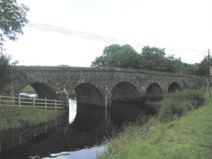 Big BridgeBridge · 2.2 mi
Explorer Tom Big Bridge was run by a matchmaker who paired off every couple crossing it, leading to local chaos. The locally-sourced stone remembers all those awkward introductions and handshakes. Listen for echoes of old gossip bouncing off these attractive rural walls.
 Kesh CorannMountain / peak · 2.3 mi
Explorer Tom Kesh Corann in County Sligo is basically the uncle at the wedding who won't stop talking about his harpist ancestor. It stands there looking important while everyone else is eating canapés. Have a sandwich here and call it a heritage lunch.
School CaveCave · 2.8 miExplorer Tom School Cave has an unlikely celebrity friend who is actually just a very confused sheep that lives in there part-time. The name suggests education, but I suspect the only lesson here is about humility and low ceilings. Tell it a joke, it's been a long time since anyone did.
.jpg/250px-Emlaghfad_Church_ruins,_south_and_west_faces,_Ballymote,_County_Sligo_(20220721_175059_655).jpg "Photo: Deirge O'Dhaoinebeaga, Wikimedia Commons · CC BY-SA 2.0") Emlaghfad Church (in Ruins)Church · 3.1 mi
Emlaghfad Church (in Ruins)Church · 3.1 miExplorer Tom Emlaghfad Church: Its family tree is mostly made up of guys named Colmcille and other people who probably didn’t even exist in the first place. It’s got a three-storey tower that looks like it’s trying to reach for a drink but can’t quite get there. Bring a pen pal, they'll be jealous.
Treanscrabbagh caveCave · 3.6 miExplorer Tom Treanscrabbagh cave reorganizes its stalactites when nobody's looking, just to keep us on our toes during the tours. It’s got that mystical energy that makes you want to whisper so as not to wake the ghosts. Ring your granny and tell her where you are.
 Ballymote CastleCastle · 4.0 mi
Explorer Tom Ballymote Castle has a grand outline and no central keep, which is enough to make me suspect the builders enjoyed proving a point. Raised around 1300 in Sligo, it is one of Connacht's last Norman castles. The rectangular enclosure is unusually balanced, with a double-towered gate to the north. Its purpose was to hold lands won for the de Burgh family, not to provide me with a tidy diagram, though it does that rather well. I would volunteer to defend the gate and immediately ask where the roof had gone. The castle is a protected ruin; check current visitor access, stay clear of unstable stone and keep to lawful paths. Walk the perimeter before choosing a corner. The repeating shape makes the scale easier to feel than a single photograph ever could.
 Carrowkeel neolithic siteArchaeological place · 4.1 mi
Explorer Tom Carrowkeel sends you into Sligo's Bricklieve Hills to meet monuments that were old before most of our stories began. The passage tombs were built in the fourth millennium BC, overlooking Lough Arrow. Excavators came in 1911 and found remains and pottery; one distinctive pottery type became known as Carrowkeel Ware. Their Bronze Age date was wrong, though. Later research placed use of these tombs around 3500 to 2500 BC. I get a date wrong at dinner and hear about it for weeks; archaeology at least has the sense to correct itself. The old excavations also removed human remains, so the place is more than an ancient puzzle laid out for our entertainment. These are protected monuments on open hills, reached on foot over uneven ground. Check local access and weather, and leave the chambers and stones exactly as you found them. I'll keep my theories to the path, where they cannot loosen anything.
 Bricklieve MountainsMountain / peak · 4.2 mi
Explorer Tom The Bricklieve Mountains have had so many names they should really be asking for a royalty check. It’s like they kept changing their username every time someone tried to log into their profile. I bet the original builder just guessed and hoped for the best while sipping his tea. Wave at the cows, they're the real locals.
 Fighting 69th MonumentMonument · 4.2 mi
Explorer Tom Fighting 69th Monument in County Sligo is mostly ignored by the local rabbits, who think it’s just another giant rock they can nap against without getting kicked off. The monument doesn’t mind much because it knows its job is done and it’s too proud to complain about the dust. Linger, it's not going anywhere and neither should you.
_-_geograph.org.uk_-_4073636.jpg/250px-Castles_of_Connacht,_Moygara,_Sligo_(2)_-_geograph.org.uk_-_4073636.jpg "Photo: Mike Searle, Wikimedia Commons · CC BY-SA 2.0") Moygara Castle (in Ruins)Bawn · 4.4 mi
Moygara Castle (in Ruins)Bawn · 4.4 miExplorer Tom Moygara Castle has made a New Year’s resolution to stop leaning over so much and start standing straighter. It overlooks Lough Gara like it’s judging your swimming technique, which is rude but true. Bring wellies and low expectations, leave delighted.
 New Kilmorgan Burial GroundCemetery · 4.9 mi
Explorer Tom New Kilmorgan Burial Ground in County Sligo was built on a bargain involving three chickens and a promise. I’m pretty sure the chickens were just eggs, but whatever. Bring curiosity, leave with a better story than mine.
More archaeology and monuments in County Sligo · All of County Sligo

What do you know about this place?Tap to add a comment or ask a question