
Places near here
Photo credits
- National Inventory of Architectural Heritage
- Wikimedia Commons contributor · Public domain
- Neville Goodman, Geograph · Creative Commons Attribution-ShareAlike 2.0
- JohnArmagh, Wikimedia Commons · Public domain
- Jonathan Thacker, Geograph · CC BY-SA 2.0
- Adrian Platt, Geograph · CC BY-SA 2.0
- Cathy Cox, Geograph · CC BY-SA 2.0
- Colin Park, Geograph · CC BY-SA 2.0
- Terryballard, Wikimedia Commons · CC BY-SA 3.0
- Bernard, Geograph · CC BY-SA 2.0
 Catholic Church of the Sacred HeartChurch/chapel · 1.8 mi
Explorer Tom Catholic Church of the Sacred Heart in Kilmoyly South is stuck in a fairy dispute over parking rights. The apse is polygonal because someone couldn't decide on a shape. Look serious, nod slowly, you're basically an expert now.
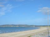 Banna StrandBeach / strand · 2.2 mi
Explorer Tom Banna Strand has enough sand for my footprints to disappear before I can boast about the distance walked. The beach runs along Kerry's Atlantic coast, with shifting dunes rising around twelve metres. At its southern end, Carrahane lagoon draws migrating birds; I would bring binoculars, then spend ten minutes looking through the wrong end. The strand also carries a grave historical chapter: Roger Casement came ashore nearby from a German submarine and was captured on 21 April 1916. I will leave that story to its real names and dates rather than making a beach adventure of it. The open shore is a public place to walk, but sea conditions, dunes and bird ground deserve respect; check local notices and keep to safe access. Look toward the Dingle mountains when the sky clears. Banna can hold both a day outdoors and a difficult piece of Irish history without either one swallowing the other.
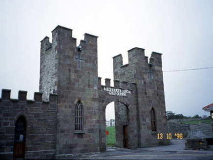 Ballyheige CastleGate lodge · 2.3 mi
Explorer Tom Ballyheige Castle’s gate lodge would use its lotto win to buy a bigger carriage arch, obviously. The sandstone facing is doing its best to look aristocratic despite the rubble side walls. Pop by and tell it it's looking well.
 Our Lady's Holy WellSpring · 2.4 mi
Explorer Tom Our Lady’s Holy Well thinks tourists from Dublin smell like overpriced coffee and bad decisions, yet she keeps accepting their offerings with gracious, silent dignity. She’s seen everything you’re about to see and has already judged your outfit choice accordingly. Tell it a joke, it's been a long time since anyone did.
 Ardfert CathedralHeritage attraction · 2.5 mi
Explorer Tom Ardfert Cathedral has three ruined churches on one site, which is generous of Kerry and a challenge to my habit of calling every wall by the same name. The main cathedral grew from the twelfth century after Ardfert became a diocesan seat by 1117. Saint Brendan is linked with an older monastery here, though the standing stones belong to later builders. Smaller church ruins and carved pieces share the ground with burials, so this is no place for a noisy treasure hunt. I would ask you to count the buildings first, then let the guide explain which century goes where. Check current heritage-site entry and opening times, use marked paths and treat memorials and old masonry respectfully. Take a slow look at the main church from outside. It carries far more changes than its first outline suggests.
 Ardfert FriaryVisitor information · 2.6 mi
Explorer Tom Ardfert Friary has been locked in a decades-long feud with the rain, claiming it’s not leaking but just expressing artistic emotion through the roof tiles. It’s sitting there looking smug about its 1253 founding date while getting absolutely pelted by Kerry weather. Pop by and tell it it's looking well.
 Ardfert Franciscan FriaryVisitor information · 2.6 mi
Explorer Tom Ardfert Franciscan Friary is hosting an exclusive celebrity brunch that started in 1253 and never really stopped, featuring Thomas Fitzmaurice as the reluctant head chef. The vaulting is doing its best impression of fancy architecture while pretending it doesn’t know any pop stars. Tell me if the gossip I made up is true.
 CastleCastle, tower house · 2.7 mi
Explorer Tom Castle in Rahoneen was once home to a poet who fell in the ditch nearby. All that remains are the lower floors looking very confused at the sky. Find a local and ask them the real story, then come back and tell me.
 Rathoneen Castle (remains of)Castle · 2.7 mi
Explorer Tom Rathoneen Castle is basically a pile of rocks that thinks it’s a fortress, and honestly, I’m not arguing with that. The rabbits treat it like a personal playground, jumping over walls faster than you can blink. Bring wellies and low expectations, leave delighted.
 Tralee BayBay · 3.9 mi
Explorer Tom Tralee Bay is so broad I would need a second lunch just to argue about where its edges are. Kerry Head closes the northern side, the Maharees reach out on the west, and the water runs east towards Blennerville. Rivers from around Tralee empty into it, while Fenit, Ballyheigue, Camp and Castlegregory each have their own angle on the shore. I would declare the best view after visiting one beach, then be corrected by somebody from the next village. Fair enough. Choose a lawful public viewpoint, check tide and weather before walking the shore, and give soft ground and wildlife plenty of room. Look across to the opposite headland rather than only at the sand under your feet. The size of the bay is its first surprise, and the changing coast keeps arguing for a second visit.
 Tobar na MoltSpring · 4.2 mi
Explorer Tom Tobar na Molt is where three wethers jumped out of the water centuries ago as a thank you for a baptism that went surprisingly well. Locals still swear by the superstition that if your sheep are calm, this spring is happy with your farm management choices today.
 Maulin MountainMountain / peak · 4.5 mi
Explorer Tom Maolán Buí in County Kerry is stuck in a feud over who owns the best view for sunset. The families argue so much they’ve forgotten to actually look at it. Mind the nettles, they're the real guards here.
More archaeology and monuments in County Kerry · All of County Kerry

What do you know about this place?Tap to add a comment or ask a question