Places near here
Photo credits
- Wanfried-Dublin, Wikimedia Commons · CC BY-SA 3.0
- Kenneth Allen, Wikimedia Commons · CC BY-SA 2.0
- Kenneth Allen, Geograph · Creative Commons Attribution-ShareAlike 2.0
- Kenneth Allen, Geograph · CC BY-SA 2.0
- N Chadwick, Geograph · CC BY-SA 2.0
- Alastair Rae, Wikimedia Commons · CC BY-SA 2.0
- N Chadwick, Geograph · Creative Commons Attribution-ShareAlike 2.0
- HENRY CLARK, Geograph · CC BY-SA 2.0
 Ram's IslandIslet · 2.1 mi
Explorer Tom Ram's Island grew while everyone was looking the other way. It is Lough Neagh's largest island, and lowering the lake in the nineteenth century expanded it from roughly six acres to twenty-five. A medieval round tower survives among the trees. Wolfe Tone and other men who helped found the United Irishmen visited in 1795, another reason this wooded island has more history than its small outline suggests. I would claim my arrival caused the lake to step back, but the dates make that a difficult boast. The island has no road connection; check current boat access, landing permission and weather before making a trip. Give wildlife and the old tower space, and never climb fragile remains. Look from the water first. The shoreline itself has moved since some of those visitors came here.
 Ballinderry Moravian ChurchChurch · 2.9 mi
Explorer Tom Ballinderry Moravian Church thinks the road leading to it is too slow and rude, which says a lot about its personality. It’s been standing since the 1820s, just waiting for a better commute. Stand still and listen, the wind tells it better than me.
 Ballinderry HouseHouse · 3.1 mi
Explorer Tom Ballinderry House is an old joint from the 1740s that holds a fake world record for being ignored by tourists. It’s fancy but lonely, like a rich uncle who forgot to invite you to dinner. Tell it a joke, it's been a long time since anyone did.
 C17th church & graveyard: ballinderry new church in BallinderryC17th Church & Graveyard: Ballinderry New Church · 4.4 mi
Explorer Tom C17th church & graveyard: Ballinderry new church in Ballinderry would teach history by pointing at its nail-free roof and saying 'look how clever these guys were without a power drill.' It’s the seventeenth century’s answer to modern engineering, proving you don’t need metal to hold things together. Great spot to propose. Or at least to propose lunch.
 Main StreetVisitor information · 5.0 mi
Explorer Tom Main Street has been avoiding a certain bishop who refuses to visit because he thinks the pavement is too narrow for his dignity. The street just laughs and carries on, letting him stew in his own self-importance from afar. It’s very cheeky of it. It's free, it's odd, what more do you want?
 Lough Neagh Discovery CentreHeritage attraction · 5.0 mi
Explorer Tom Lough Neagh Discovery Centre near Lurgan hides a message in its stones that says 'please stop taking selfies', which is the only honest thing it does. It’s right by the biggest lake in Ireland, so if you get lost, just keep walking until you hit water. Snap one photo, then put the phone away and actually look.
 Battle site, 1003 AD & 1099 AD in CrewBattle Site, 1003 AD & 1099 AD · 6.1 mi
Explorer Tom Battle site, 1003 AD & 1099 AD in Crew has fought twice, which is impressive for a patch of grass that looks like it’s never had a proper argument. Saint Patrick probably looked at it and said 'you two need to stop picking on each other' before walking away in a huff.
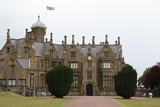 Brownlow HouseMuseum · 6.6 mi
Explorer Tom Brownlow House in Lurgan was designed by a mother-in-law who really knew how to make guests feel unwelcome, or so the legend goes. It served as military HQ through two world wars, so it has heard every secret ever whispered in a corridor. Have a chat with it, nobody's watching.
 Medieval parish church (site of) & c17th church & graveyard: lan in MagheralinMedieval Parish Church (site of) & C17th Church & Graveyard: Lan · 7.0 mi
Explorer Tom Lan in Magheralin has a medieval parish church site and a 17th-century church, so it’s basically a history lesson with a side of graveyard atmosphere. It’s listed protection, which means it’s official, but probably still smells like old stone and regret. Look up, the best bit is always higher than you think.
 Pre-norman Monastery, & Later Church & Graveyard: Arboe or Ardboe Abbey in FarsnaghPre-norman Monastery, & Later Church & Graveyard: Arboe or Ardboe Abbey · 8.2 mi
Explorer Tom Pre-norman Monastery, & Later Church & Graveyard: Arboe or Ardboe Abbey in Farsnagh is stuck in a fairy dispute over who gets parking rights next to the gate. It’s seen centuries of monks and muck, so it doesn't sweat the small stuff too much. Bring a jacket, it's never as warm as I promise.
 Waringstown Red WoodsForest · 8.8 mi
Explorer Tom Waringstown Red Woods is incredibly proud of its redness, acting like every other tree in County Down is just a jealous green impostor trying to steal the spotlight. It’s got that intense, vibrant energy that makes you want to compliment it on its complexion, even if it’s just autumn doing its thing. Have a wander and a wonder.
 Belshaw's Quarry Nature ReserveNature reserve · 9.1 mi
Explorer Tom Belshaw's Quarry Nature Reserve claims to be older than the rocks you think are old, which is nonsense. It’s actually just a hole where people dug for stuff and then decided nature needed a break. Look for the ghost, then pretend you didn't see him waving awkwardly from the shadows.
More cliffs, bays and coast in County Antrim · All of County Antrim

What do you know about this place?Tap to add a comment or ask a question