
Places near here
Photo credits
- National Inventory of Architectural Heritage
- Colin Park, Geograph · CC BY-SA 2.0
- Oliver Dixon, Geograph · Creative Commons Attribution-ShareAlike 2.0
- Discover Lough Derg, Wikimedia Commons · CC BY-SA 2.0
- P L Chadwick, Geograph · CC BY-SA 2.0
- Andreas F. Borchert, Wikimedia Commons · CC BY-SA 4.0
- Roger Diel, Geograph · CC BY-SA 2.0
- David P Howard, Geograph · CC BY-SA 2.0
- Willow, Wikimedia Commons · CC BY 2.5
- JP, Geograph · CC BY-SA 2.0
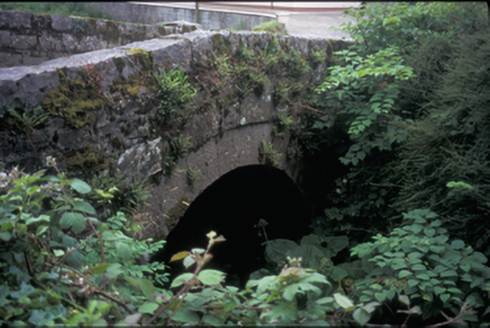 bridge1.4 mi
Explorer Tom Bridge in Kilbane is planning retirement to a sunny beach somewhere where no one needs to cross a river ever again. It’s been here since 1820, so it’s basically ancient history with a road on top. Make a wish, it's had centuries of practice.
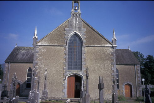 Saint Mary's Catholic ChurchChurch/chapel · 1.5 mi
Explorer Tom Saint Mary's Catholic Church in Kilbane is a Gothic Revival beauty from around 1850 with some very serious pinnacles. It’s got replacement uPVC windows, which feels like wearing a tuxedo to a barbecue. Snap one photo, then put the phone away and actually look.
 MoylussaMountain / peak · 2.6 mi
Explorer Tom Moylussa is Clare's highest point at 532 metres, and I will let it enjoy the title without asking for a taller rival. The mountain rises west of Lough Derg, above forest and open moor. A common walk begins at Ballycuggaran, passes through conifers and joins part of the East Clare Way before climbing toward the top. A shale path now helps walkers reach the summit marker. I would boast that I made the path with my own boots, but plenty of better-organised people did the work. Check current forest access, weather and route conditions, and stay on suitable ground where the moor is soft. From the top, turn toward Lough Derg and the Shannon country. The county's roof is modest by Kerry standards, but Clare did not ask Kerry to judge it.
 TobermurraghHoly well · 3.6 mi
Explorer Tom Tobermurragh in Knockyclovaun was once taken over by a fox who demanded tribute in exchange for guarding the water supply. The red brick enclosure stands as a monument to that brief but chaotic reign of canine authority and questionable judgment. Linger, it's not going anywhere and neither should you, really.
.jpg/250px-Brian_Boru's_Fort_(51357382309).jpg "Photo: Discover Lough Derg, Wikimedia Commons · CC BY-SA 2.0") Brian Boru FortHeritage attraction · 3.7 mi
Brian Boru FortHeritage attraction · 3.7 miExplorer Tom Brian Boru's Fort is a grand name, and I would be the first to announce the king built every bank by hand. Archaeology asks for more care. Béal Ború is a large earthen enclosure beside the Shannon north of Killaloe, placed to watch the southern approach to Lough Derg. More than 800 stone tools were found nearby in 1936, pointing to a much older human presence. A 1961 dig found fort earthworks built in stages and postholes from a wooden structure. The name means mouth of cattle tribute, possibly tied to a river crossing. Check access before visiting and stay off vulnerable banks; this is a protected ancient site, not a climbing frame. Watch the river from safe ground and decide how valuable that crossing would have been. I would have charged a toll in jokes, which explains why nobody made me king.
 Brian Boru Heritage CentreVisitor information · 3.9 mi
Explorer Tom Brian Boru Heritage Centre in County Clare is hiding a treasure chest inside the library that definitely contains nothing but stale biscuits and old newspapers. The lock-keeper’s ghost is still guarding it for no reason. Ten minutes here and you'll have a yarn for the pub.
 Cath.Cathedral · 3.9 mi
Explorer Tom Cathedral in Shantraud is hiding its light under a very large bushel of mystery. The locals probably think the roof leaks because they forgot to pay the celestial plumber. It’s a proper spot for a flask of tea and a big, confused think about history.
 Aharinagh CastleArchaeological place · 4.1 mi
Explorer Tom Aharinagh Castle is where a giant once dropped his keys and never found them, according to local myth. It’s an archaeological place now, which means 'come look at dirt with rocks in it' but fancier. The ground feels squishy, like the earth is trying to swallow your boots whole. Visit, then text me what you think. I'll pretend to read it.
Aharinagh Castle (in ruins)Castle, unclassified · 4.1 miExplorer Tom Aharinagh Castle in Ballybrack feels like it was designed by a very angry mother-in-law who hated guests. The whole vibe is 'don't touch my stuff.' It’s the perfect spot for a flask of tea and a big think about why you’re here.
 Rinnaman PointHeadland · 4.2 mi
Explorer Tom Rinnaman Point is the person at the wedding who stands in the corner judging everyone's outfit while pretending they are too busy looking at the sea. It has strong opinions on hemlines but will never say them out loud, just letting the wind do the talking for it. Go back in winter, it's a different animal.
 European ash5.6 mi
Explorer Tom European ash in County Clare had a New Year’s resolution to grow one more leaf per year, but it’s been stuck at zero for decades now. It’s basically just a stick pretending to be a tree, waiting for spring that never quite comes. Bring a flask and pretend you own the place.
 Crow IslandIslet · 7.2 mi
Explorer Tom Crow Island in County Clare hosted a fiddler who played all night until his fingers turned into crows and flew away. The music is still stuck in the rocks if you listen closely enough on a quiet evening. Ideal stop for a big stretch and a bigger yawn.
More mountains and hills in County Clare · All of County Clare

What do you know about this place?Tap to add a comment or ask a question