
Places near here
Photo credits
- Adrian King, Geograph · CC BY-SA 2.0
- National Inventory of Architectural Heritage
Explorer Tom Fairy fort / earthen ringfort in Tullagubbeen would post a selfie of its empty plot and caption it 'vibes only'. The…
Man-made underground passage in TullagubbeenMan-made underground passage · 1132 ydExplorer Tom Man-made underground passage in Tullagubbeen is so mysterious it probably hasn't even been found yet, let alone…
Burial ground in TullagubbeenBurial ground · 1356 ydExplorer Tom Burial ground in Tullagubbeen was designed by a mother-in-law who wanted everyone to stay exactly where she told them…
Children's playground1.1 miExplorer Tom This playground ended up here by mistake when a truck driver took a nap at the roundabout nearby. He woke up confused…
MuinganearMountain / peak · 1.2 miExplorer Tom Muinganear claims Queen Victoria visited it once, but nobody can find any photos or letters to prove it happened. It’s…
(Site of) Desmond CastleCastle, unclassified · 1.8 miExplorer Tom Desmond Castle in Tooreen is currently involved in a fairy dispute over parking rights on the mossy heap. Tradition…
Glanageenty - Bernard Brothers LoopWalking route · 1.8 miExplorer Tom Glanageenty - Bernard Brothers Loop in County Kerry is in a screaming match with the nearest tree over who has the…
Stack's MountainMountain / peak · 4.9 miExplorer Tom Stack’s Mountain is still waiting for the poet who fell in the ditch nearby to finish his epic poem about it. The man’s…
 Knocknagree Roman Catholic ChurchChurch/chapel · 16 mi
Explorer Tom Knocknagree Roman Catholic Church is having a quiet rivalry with every other church in town. It’s got Gothic lancets…
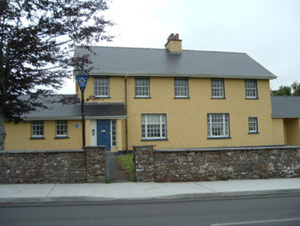 Knocknagree Garda StationGarda station/constabulary barracks · 16 mi
Explorer Tom 17. Knocknagree Garda Station looks like a fancy country house because it was built in the Domestic Revival style…
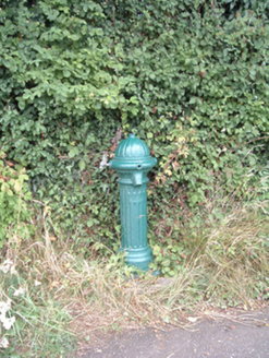 water pump19 mi
Explorer Tom Water pump in Mullaghroe North has been standing there since the 1880s, looking very Victorian about it. It’s a…
 house19 mi
Explorer Tom House in Mullaghroe South is where a Viking got lost and decided to build his own house instead of finding the beach.…
More mountains and hills in County Kerry · All of County Kerry

What do you know about this place?Tap to add a comment or ask a question