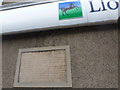
What is recorded here
This commemorative plaque records: Near this spot, facing Broad Street, stood, in the year 1865, the last remaining fragments of the ruins of the castle of Kirkwall. A royal fortress of great antiquity and originally of vast strength, but of which from the ravages of war and time nearly every vestige had long previously disappeared. Its remains, consisting of a wall 55 feet long by 11 feet thick and of irregular height, were removed by permission of the Earl of Zetland on application of the trustees acting in execution of the Kirkwall Harbour Act 1859 in order to improve the access to the harbour, and this stone was erected to mark the site. MDCCCLXVI [1866]
Kirkwall Castle served as a royal fortress of significant antiquity, playing a crucial defensive role in Orkney's history until its demolition in the 19th century to improve harbor access.
A plaque record does not grant entry to a building or private land. View it from a public place unless permission is clearly given.
Places near here
 Kirkwall, 4 Broad StreetTown House (19th Century) · 40 yd
 Kirkwall, Castle Street, Masonic HallMasonic Hall (19th Century) · 55 yd
 Kirkwall, Albert Street, the Big TreeTree (period Unknown) · 56 yd
 Kirkwall, St Magnus Cathedral, War MemorialWar Memorial (20th Century), War Memorial (20th Century) (1923) · 59 yd
 Kirkwall and St. Ola War MemorialMemorial · 61 yd
 Town HallMuseum · 77 yd
.jpg?width=1280) Orkney MuseumMuseum · 122 yd
Orkney MuseumMuseum · 122 yd Kirkwall Tourist InformationVisitor information · 126 yd
 Kirkwall, Tankerness HouseNo Class (event) (20th Century) · 127 yd
 Grain Earth HouseVisitor information · 1103 yd
 Orkney, KirkwallNo Class (event) (21st Century) · 1398 yd
 RNAS Hatston MemorialMemorial · 1.1 mi
Other information
Photo: Chris Downer on Geograph · CC BY-SA 2.0