
What is recorded here
Kilpatrick is a burgh in West Dunbartonshire, Scotland.
Places near here
Photo credits
- Lairich Rig, Wikimedia Commons · CC BY-SA 2.0
- Maker not stated on source page, en.wikipedia.org
- Thomas Nugent, Wikimedia Commons · CC BY-SA 2.0
- Tim Glover, Wikimedia Commons · CC BY-SA 2.0
- N Chadwick, Wikimedia Commons · CC BY-SA 2.0
- Maker not stated on source page, www.wikidata.org
- Maker not stated on source page, www.pinterest.com
- Maker not stated on source page, www.history-channel.org
 The SaltingsNature reserve · 456 yd
Explorer Tom The Saltings sits below the Erskine Bridge, where concrete and river make an unlikely frame for meadow, woodland and…
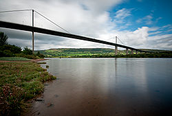 River Clyde, Erskine Bridge, Mine Watchers PostGraffiti (21st Century), Observation Post (second World War) · 595 yd
 Old KilpatrickTown · 641 ydErskine, Erskine BridgeRoad Bridge (20th Century) · 678 yd
 Old Kilpatrick, Forth and Clyde Canal, CulvertCulvert · 684 yd
 River Clyde, ErskineSea Defences (18th Century) · 702 yd
 Old Kilpatrick, 83-7 Dumbarton Road, Old Secession ChurchChurch (19th Century) - (20th Century) · 733 yd
 War MemorialMemorial · 823 yd
 Kilpatrick BraesVisitor information · 1010 yd
 Unknown: Bowling Harbour, River ClydeCraft · 1579 yd
 Big WoodWood · 1580 yd
 Mapped graveyardGraveyard · 1.0 mi
More archaeology and monuments in West Dunbartonshire · All of West Dunbartonshire

What do you know about this place?Tap to add a comment or ask a question