
What is recorded here
From OpenStreetMap (© OpenStreetMap contributors) n11765904685
Places near here
Picture notes
- Computer-made picture. It does not show this monument.
- National Inventory of Architectural Heritage
- Computer-made picture. It does not show this playground.
- Computer-made picture. It does not show this mountain top.
- Eric Jones, Geograph · CC BY-SA 2.0
 Fairy fort / earthen ringfort in KilnagarbetFairy fort / earthen ringfort · 286 ydTom: I’m here to help · Computer-made picture. It does not show this monument.
Explorer Tom Kilnagarbet Fairy Fort is so denuded it looks like it lost its hair in a bad year! Saint Patrick would have probably sighed and moved on to something with more substance. Stand still and listen, the wind tells it better than me.
 Fairy fort / earthen ringfort in Drumhallagh (tullygarvey By.)Fairy fort / earthen ringfort · 545 ydTom: I’m here to help · Computer-made picture. It does not show this monument.
Explorer Tom Fairy fort / earthen ringfort in Drumhallagh is on a steep hillside next to a stream, but they've levelled it off completely. It used to be marked as a fort, but now it's just a nice pasture with a secret past. Bring a notebook and write the bit I made up.
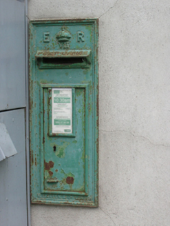 post box1212 yd
Explorer Tom Post box in Larah has been collecting mail for over a century while pretending to be an Edwardian icon. It’s just a tin can with a crown, but act surprised when you find it!
 St Mark's Church of Ireland ChurchChurch/chapel · 1270 yd
Explorer Tom St Mark's in Killycrone is all Perpendicular Gothic, which sounds like a type of yoga but isn’t. It replaced an older church that probably had better gossip going on. Have a chat with the graveyard gates if they look friendly enough for you!
 Laragh PlaygroundChildren's playground · 1308 ydTom: I’m here to help · Computer-made picture. It does not show this playground.
Explorer Tom With access confirmed, Laragh Playground is definitely the spot for your little ones to burn off endless energy in County Cavan.
 Foundation Stone Blessed by Pope John Paul II 1979Memorial · 1376 yd
Explorer Tom This foundation stone was blessed by Pope John Paul II in 1979, marking a significant moment for County Cavan.
 DrumgoneyMountain / peak · 1.2 miTom: I’m here to help · Computer-made picture. It does not show this mountain top.
Explorer Tom Drumgoney is a Cavan peak that seems to be keeping a very close eye on the horizon, maybe waiting for a dragon or something similar.
Giant's GraveArchaeological place · 1.3 miExplorer Tom This Giant's Grave is a proper archaeological mystery, tucked away in the lovely green fields of Cavan.
 CordinginMountain / peak · 1.3 miTom: I’m here to help · Computer-made picture. It does not show this mountain top.
Explorer Tom Cordingin is a quiet mountain peak in County Cavan, probably just watching the clouds drift by slowly.
Killymeehan ForestForest · 1.6 miExplorer Tom Killymeehan Forest feels like a quiet retreat in County Cavan, perfect for getting lost in the rustling leaves and fresh air.
 Children's playground1.7 miTom: I’m here to help · Computer-made picture. It does not show this playground.
Explorer Tom Maybe this Children's playground in County Cavan has a swing set that goes straight up to the moon.
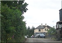 Cormeen Glebe ForestForest · 1.8 mi
Explorer Tom Cormeen Glebe Forest near Clifferna, County Cavan, feels like a peaceful retreat; perhaps a farmhouse ghost is waving from the trees.
More mountains and hills in County Cavan · All of County Cavan
What do you know about this place?Tap to add a comment or ask a question