What is recorded here
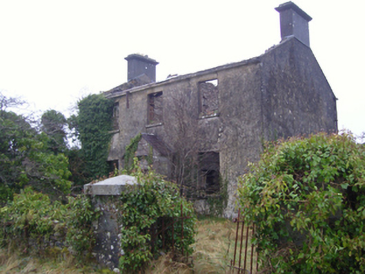
Detached three-bay two-storey constabulary barrack, designed 1873; built 1873; opened 1874, on a T-shaped plan centred on single-bay single-storey gabled advanced porch to ground floor. Occupied, 1901; 1911. Attacked, 1921. Reconstructed, 1926, to accommodate alternative use. Closed, 1956. Now in ruins. Pitched slate roof now missing with rendered chimney stacks having ogee-detailed stringcourses below capping supporting yellow terracotta pots, and remains of cast-iron rainwater goods on cut-limestone eaves retaining cast-iron downpipes; pitched (gabled) slate roof (porch) with clay ridge tiles. Part ivy-covered rendered walls. Square-headed central door opening in camber-headed recess with benchmark-inscribed step threshold, and concealed dressings with no fittings surviving. Square-headed window openings with cut-limestone sills, and concealed red brick block-and-start surrounds framing remains of six-over-six timber sash windows. Interior in ruins. Set in unkempt grounds with tooled limestone ashlar piers to perimeter having cut-limestone shallow pyramidal capping supporting wrought iron double gates.
A constabulary barrack erected to designs examined (1873) by Enoch Trevor Owen (c.1833-81), Assistant Architect to the Board of Public Works (appointed 1863), representing an important component of the later nineteenth-century built heritage of Kilmovee with the architectural value of the composition, one recalling the contemporary Kinnewry Constabulary Barrack (1873-4), Kinnewry (see 31309901), confirmed by such attributes as the compact rectilinear plan form centred on a windbreak-like porch; and the very slight diminishing in scale of the openings on each floor producing a feint graduated visual impression. Although reduced to ruins following a prolonged period of neglect, the form and massing survive intact together with remnants of the original fabric, thus upholding some of the character or integrity of a constabulary barrack making a picturesque, if increasingly forlorn visual statement in a sylvan setting: meanwhile, a discreet benchmark remains of additional interest for the connections with cartography and the preparation of maps by the Ordnance Survey (established 1824).
This does not grant access. Most recorded buildings are privately owned; view them only from public ground unless the owner allows entry.
Places near here
 IndicatedEnclosure · 328 yd
 Catholic Church of the Immaculate Conceptionchurch/chapel · 1332 yd
 CashelFairy fort / stone ringfort · 1.0 mi
 Church in Rusheens WestChurch · 1.0 mi
 Crunaun Castle (in ruins)Castle, unclassified · 3.9 mi
 Casatle (ruins)Castle, unclassified · 4.2 mi
 Bockagh HillMountain / peak · 4.9 mi
 East Mayo Brigade MonumentMemorial · 6.5 mi
 Bawn IslandIslet · 11 mi
 Clonalis HouseMuseum · 11 mi
 Knock ShrineHeritage attraction · 11 mi
 Rose PointHeadland · 11 mi
Other information
Photo: National Inventory of Architectural Heritage · Website use allowed for educational or private purposes with source credit