What is recorded here
Excavation licence number 01D083. Test-trenching was carried out in advance of a pier extension scheme that will involve the partial removal and burial of a gravel bar in Killybegs Harbour. The north end of Smooth Point (SMR 97:16) had been investigated by a programme of test-trenching carried out by Archaeological…
Read the whole record
From the National Monuments Service (Archaeological Survey of Ireland) record DG097-016
Places near here
Photo credits
- Maker not stated on source page, www.travelandleisureasia.com
- Maker not stated on source page, commons.wikimedia.org
- Andreas F. Borchert, Wikimedia Commons · CC BY-SA 4.0
- National Inventory of Architectural Heritage
- Maker not stated on source page, www.tripadvisor.de
- Kenneth Allen, Geograph · CC BY-SA 2.0
- David Dixon, Wikimedia Commons · CC BY-SA 2.0
 CastleCastle, unclassified · 244 yd
Explorer Tom Castle at Killybegs was probably a McSwyne stronghold. A 1622 record described a ruinous castle beside a stone bawn; an…
 St Catherine's Friary GraveyardGraveyard · 410 yd
Explorer Tom St Catherine's Friary Graveyard encloses a church with more than one chapter. The ruins may be part of an earlier…
 St Catherine's Friary GraveslabGraveslab · 410 yd
Explorer Tom St Catherine's Friary Graveslab marks John Lindsey, who died young at twenty-seven back in 1685. The slab is broken and…
 St Catherine's Church and FriaryChurch · 411 yd
Explorer Tom St Catherine's Church and Friary may preserve an older friary in a church altered across several centuries. The survey…
 St. Catherine's GraveyardCemetery · 415 yd
Explorer Tom St. Catherine's Graveyard in County Donegal has a ridiculous smuggling story involving a barrel of whiskey and a very…
 St Catherine's WellHoly well · 419 yd
Explorer Tom St Catherine's Well in Killybegs was once a famous pilgrimage site, but there’s a daft legend that a Protestant rector…
 Kit's Castle (Ruins)Castle · 465 yd
Explorer Tom Kit’s Castle (Ruins) sounds like it belongs to a kid who lost his hat. I wonder if Kit was famous for being really…
 Cat CastleCastle, tower house · 465 yd
Explorer Tom Cat Castle is named after St. Catherine, but really it’s just a tiny stone corner standing on a hill above Killybegs…
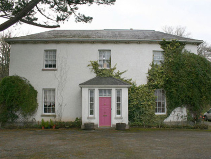 The Old Rectory or St. Catherine'sRectory/glebe/vicarage/curate's house · 579 yd
Explorer Tom The Old Rectory or St. Catherine's sits near a church that was fixed up back in 1622! That’s so long ago I can’t even…
 The Marina CafeRestaurant · 631 yd
Explorer Tom The Marina Cafe smells like fish died nearby, but that’s just the aroma of fresh seafood. It was nearly sold for a…
 Harbour BarPub · 700 yd
Explorer Tom Harbour Bar probably smells like old fish and bad decisions, because that’s what 'harbour' really means in this…
 Rashenny PointHeadland · 1181 yd
Explorer Tom Rashenny Point in County Donegal was once the prime spot for smuggling contraband teacups and very suspiciously large…
More archaeology and monuments in County Donegal · All of County Donegal

What do you know about this place?Tap to add a comment or ask a question