Places near here
Photo credits
- Andreas F. Borchert, Wikimedia Commons · CC BY-SA 4.0
- National Inventory of Architectural Heritage
- User:Itub, Wikimedia Commons · CC BY-SA 3.0
- Mike Searle, Wikimedia Commons · CC BY-SA 2.0
- Ridiculopathy, Wikimedia Commons · CC BY-SA 4.0
- Keith Cunneen, Geograph · CC BY-SA 2.0
- Britishfinance, Wikimedia Commons · CC BY-SA 4.0
Explorer Tom Saint Patrick looked at this Knockavota enclosure and just sighed deeply before walking away. He couldn’t be bothered dealing with the snakes or the mud, honestly. Go on a wet day, it suits the mood.
 Killagh Abbey (in ruins)Religious house, Augustinian canons · 1547 yd
Explorer Tom Killagh Abbey thinks it’s the main character in a medieval drama, complete with a fan club that dissolved centuries ago. It’s all about that 'Beautiful Place' energy, even if the roof has given up on the whole idea. Tell the kids it's a castle; they’ll believe it.
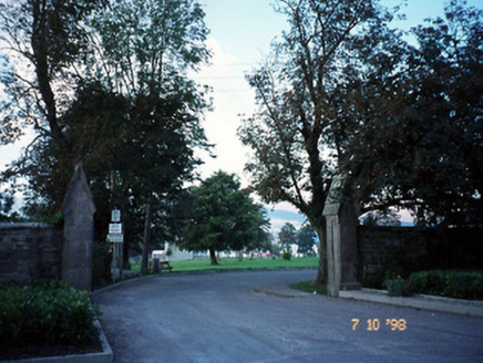 Kilcolman AbbeyGates/railings/walls · 1.0 mi
Explorer Tom Kilcolman Abbey is just two lonely piers pretending to be something grander than they are now. The map makers clearly got confused by the whole gate thing. Bring curiosity, leave with a better story than mine.
Clash IslandIslet · 1.6 miExplorer Tom Clash Island sounds like what happens when two drunk fishermen argue about whose turn it is to bail. Saint Patrick probably called it a mess before even arriving in the country. Stand back, squint, and it looks like a castle.
Cloon IslandIsland · 2.1 miExplorer Tom Cloon Island used to be run by a matchmaker who paired off lonely boats with their moorings. Now it just sits there, judging everyone who passes by with that quiet, lough-side stare. Bring sandwiches, the gulls will thank you.
 King Puck statueMemorial · 2.8 mi
Explorer Tom King Puck statue in Killorglin, County Kerry has a ghost tenant who is too lazy to haunt it because he prefers watching TV in peace. Bring a coin for luck and keep it in your pocket.
LisnagraveArchaeological place · 3.4 miExplorer Tom Lisnagrave is an archaeological place that seems to have been drawn on the map by someone who wasn't paying attention. I bet the map makers got it wrong because they were too busy eating sandwiches and looking at the view. Ring your granny and tell her where you are.
 Ballymalis Castle (in ruins)Castle, tower house · 4.2 mi
Explorer Tom Ballymalis Castle has had so many names in its lifetime that it’s basically a chameleon, changing its identity every time the river floods a bit higher. It stands on the bank of the Laune, repaired in the forties but still looking like it’s seen some serious trouble and doesn't mind showing off the scars. Bring a jacket, it's never as warm as I promise.
 Ballymalis CastleCastle · 4.2 mi
Explorer Tom Ballymalis Castle is currently run by a very stern terrier who demands a treat before you can even look at the walls. The dog barks like it owns the deed and honestly, I think it does. Stand still and listen, the wind tells it better than me.
 Ogham stone in Kilcoolaght EastOgham stone · 4.4 mi
Explorer Tom Ogham stone in Kilcoolaght East is wearing its best face while hiding behind those iron railings. Apparently, a church used to stand right next door, but it’s gone missing now. Go now, before it gets famous.
 Glanbrack MountainMountain / peak · 5.5 mi
Explorer Tom Glanbrack Mountain in Kerry is planning a lavish retirement party next autumn, inviting only the local birch trees and a few stubborn scots pines to join in. It wants to be remembered as the king of the glen, even if nobody else knows where it actually is. It's free, it's odd, what more do you want?
 BaurtregaumMountain / peak · 6.1 mi
Explorer Tom Baurtregaum means top of the three hollows, which sounds like a game I might invent to avoid saying I am lost. At 851 metres it is the highest mountain in Kerry's Slieve Mish range, rising over the eastern end of the Dingle Peninsula. Scholars suggest the three hollows are the Derrymore, Derryquay and Curraheen valleys cut into its sides. A ridge links it with Caherconree, another substantial summit. I would announce I have found a fourth hollow just to cause trouble, but the map would put me right. Plan this as a mountain walk with proper gear, navigation and weather checks, and respect farmland on the approach. From a safe height, turn around and try to identify each valley. The name becomes a landscape lesson rather than a tongue-twister.
More woods, forests and old trees in County Kerry · All of County Kerry

What do you know about this place?Tap to add a comment or ask a question