
What is recorded here
Kilcar Old Church (DG096-010005-): The parish church was in ruins in 1622 (Royal Commission, 221). The surviving church remains, 6.05m wide internally, are probably of a later date. It continued in use until 1828 when a new church (now disused) was built in Kilcar Village (Lewis 11, 1837, 58; Maguire 1920, 38). Only…
Read the whole record
From the National Monuments Service (Archaeological Survey of Ireland) record DG096-010007
Places near here
Photo credits
- Maker not stated on source page, en.wikipedia.org
- Andreas F. Borchert, Wikimedia Commons · CC BY-SA 4.0
- Maker not stated on source page, ru.pinterest.com
- Maker not stated on source page, www.dailymail.co.uk
- Maker not stated on source page, au.pinterest.com
- Maker not stated on source page, marv.livejournal.com
- National Inventory of Architectural Heritage
- Maker not stated on source page, www.dreamstime.com
- John M / Geograph, www.geograph.ie
- Gerald England, Geograph · CC BY-SA 2.0
 Bullaun stone in Cill CharthaighBullaun stone · 1 yd
Explorer Tom Bullaun stone in Cill Charthaigh just showed up in 2018 like a shy guest at a party. I bet it’s been hiding under a…
 St Carthach's Old ChurchChurch · 9 yd
Explorer Tom St Carthach's Old Church features a massive, full-length break running right through its south wall just a metre from…
 Tobermurry Bullaun CairnCairn, unclassified · 40 yd
Explorer Tom Tobermurry Bullaun Cairn surrounds a carved basin stone about forty metres northeast of the church. The stone has two…
 Inscribed stone in Cill CharthaighInscribed stone · 62 yd
Explorer Tom Inscribed stone in Cill Charthaigh is a wedge-shaped boulder tucked into a field fence, with random scores that locals…
 St Connell's Well CairnCairn, unclassified · 78 yd
Explorer Tom St Connell's Well Cairn measures 7.8 by 3.6 metres, with the well at its southwest corner. The well itself is an oval…
 St Carthach's Well CairnCairn, unclassified · 173 yd
Explorer Tom St Carthach's Well Cairn stood beside an eight-sided spring in the old survey account. The cairn measured less than a…
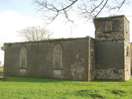 Eaglais Naomh Mhatha Eaglais na hÉireannChurch/chapel · 221 yd
Explorer Tom Eaglais Naomh Mhatha in Glaidhb An Teampaill Nua is a derelict Church of Ireland chapel that has lost its roof but kept…
 water pump346 yd
Explorer Tom Water pump in Caonachán sports a lion’s head spout that I reckon is just a very fancy dog pretending to be royalty.…
 bridge380 yd
Explorer Tom Bridge in An tamhnaigh near Caonachán is a triple-arch beauty carrying the road over with serious masonry skills. It’s…
 Relig Cill Mhic Stuice Burial GroundBurial ground · 683 yd
Explorer Tom Relig Cill Mhic Stuice Burial Ground offers a view of Tawny Bay from good pasture land, but the site itself is…
 Towney Park, KilcarGAA ground · 870 yd
 CroaghmuckrosMountain / peak · 1.0 mi
Explorer Tom Croaghmuckros in County Donegal makes a strange, creaking sound at night that locals swear is just wind, but it sounds…
More memorials and graveyards in County Donegal · All of County Donegal

What do you know about this place?Tap to add a comment or ask a question