
What is recorded here
From OpenStreetMap (© OpenStreetMap contributors) n6396680192
Places near here
Photo credits
- Maker not stated on source page, www.tripadvisor.co.uk
- Graham Horn, Wikimedia Commons · CC BY-SA 2.0
- kevin higgins, Wikimedia Commons · CC BY-SA 2.0
- Maker not stated on source page, commons.wikimedia.org
- National Inventory of Architectural Heritage
- IrishFireside, Wikimedia Commons · CC BY 2.0
- Maker not stated on source page, www.dreamstime.com
- Vicente Fernández Rioja, Wikimedia Commons · CC BY-SA 4.0
- Christian Pirkl, Wikimedia Commons · CC BY-SA 3.0 at
- Maker not stated on source page, www.alamy.com
- Tommy Murphy / Carlow Nationalist, www.carlow-nationalist.ie
 Kilbrannish Forest Picnic SitePicnic place · 696 yd
Explorer Tom Kilbrannish Forest Picnic Site in County Carlow is named after a giant who lost his lunch and never found it again.…
 CroaghaunMountain / peak · 1279 yd
Explorer Tom Croaghaun in County Carlow is the hill with a forest road to its summit, not the cliff-flinging giant on Achill Island…
 GreenogeMountain / peak · 1.1 mi
Explorer Tom Greenoge in County Carlow gave up its greenest patches for Lent because it felt like they were too showy. Now it looks…
 Standing stone in Kilbrannish NorthStanding stone · 1.2 mi
Explorer Tom Standing stone in Kilbrannish North is tilted forty-five degrees like it’s trying to make a point. It’s got that 'I was…
 Graveyard (Disused)Burial ground · 1.2 mi
Explorer Tom Graveyard (Disused) in Kilbrannish South is known as 'the Rath', which sounds way cooler than it probably is right now.…
 Hollybrook HouseHouse · 1.9 mi
Explorer Tom Hollybrook House in Bealalaw thinks Dublin tourists are a bit too loud for its 1765 Doric doorcase. It was built for…
 Adelaide Memorial Church of Christ the RedeemerChurch/chapel · 2.0 mi
Explorer Tom Adelaide Memorial Church of Christ the Redeemer in Myshall has mosaics that are judging your outfit choice. Legend says…
 Adelaide Memorial GraveyardGraveyard · 2.0 mi
Explorer Tom Adelaide Memorial Graveyard has a retirement plan that involves growing into a small hill by 2050, which it considers…
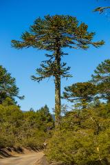 Monkey-puzzle2.0 mi
Explorer Tom Monkey-puzzle in County Carlow has an imaginary fan club that meets on Tuesdays but no one shows up. It's just sitting…
 Sycamore2.0 mi
Explorer Tom Sycamore in County Carlow would order extra thick chips with vinegar and no ketchup because it's a rebel. It knows…
 St. Finian's GraveyardGraveyard · 2.0 mi
Explorer Tom St. Finian's Graveyard would complain to the council about the lack of seating options for its ghosts. It just wants a…
 Naomh Eoin, Myshall GAA pitchGAA ground · 2.3 mi
More mountains and hills in County Carlow · All of County Carlow

What do you know about this place?Tap to add a comment or ask a question