
What is recorded here
Keith, 5 Regent Street is a house in Moray, Scotland.
From the Historic Environment Scotland record 249911
The historic-place record does not grant public access. Check current conditions and ownership before entering land or a building.
Places near here
Photo credits
- Bill Harrison, Wikimedia Commons · CC BY-SA 2.0
- Lucas Kendall, Wikimedia Commons · CC BY-SA 2.0
- Stanley Howe, Wikimedia Commons · CC BY-SA 2.0
- Alan Murray-Rust, Wikimedia Commons · CC BY-SA 2.0
- Anne Burgess, Wikimedia Commons · CC BY-SA 2.0
- Ann Harrison, Wikimedia Commons · CC BY-SA 2.0
- thejackrustles, Wikimedia Commons · CC BY-SA 2.0
 Keith, Regent Street, Old Bridge of KeithBridge (17th Century) · 35 yd
 Keith, 13 Regent Street, St RonansHouse (19th Century) · 39 yd
 Keith CemeteryCemetery (post Medieval) · 95 yd
 Keith, Old Parish Church and Burial GroundBurial Ground (post Medieval), Church (16th Century) · 160 yd
 Turner Memorial HospitalMemorial · 283 yd
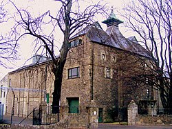 Glen Keith DistilleryDistillery · 343 yd
 Strathisla DistilleryHeritage attraction · 410 yd
 Keith, Station Road, Milton TowerTower House (medieval) · 418 yd
 Cairds HillMountain / peak · 2.3 mi
 Hill of MulderieMountain / peak · 2.8 mi
 Upper AuchairnNo Class (event) (21st Century) · 3.2 mi
 Pitlurg CastleDovecot (18th Century), Tower House (medieval) · 3.3 mi
More historic places in Moray · All of Moray
What do you know about this place?